You are here: Home > Network List > CN - Canadian National Seismograph Network Stations List
> Station INK INUVIK, NT, CANADA.ANADA > Earthquake Result Viewer
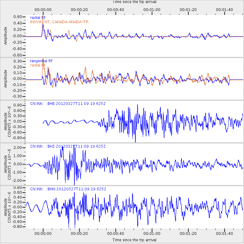
INK INUVIK, NT, CANADA.ANADA - Earthquake Result Viewer
*The percent match for this event was below the threshold and hence no stack was calculated.
| Earthquake location: |
Near East Coast Of Honshu, Japan |
| Earthquake latitude/longitude: |
39.9/142.0 |
| Earthquake time(UTC): |
2012/03/27 (087) 11:00:44 GMT |
| Earthquake Depth: |
15 km |
| Earthquake Magnitude: |
6.0 MB, 5.7 MS, 6.1 MW, 5.9 MW |
| Earthquake Catalog/Contributor: |
WHDF/NEIC |
|
| Network: |
CN Canadian National Seismograph Network |
| Station: |
INK INUVIK, NT, CANADA.ANADA |
| Lat/Lon: |
68.31 N/133.52 W |
| Elevation: |
40 m |
|
| Distance: |
51.7 deg |
| Az: |
28.148 deg |
| Baz: |
282.396 deg |
| Ray Param: |
$rayparam |
*The percent match for this event was below the threshold and hence was not used in the summary stack. |
|
| Radial Match: |
73.543594 % |
| Radial Bump: |
400 |
| Transverse Match: |
68.85204 % |
| Transverse Bump: |
400 |
| SOD ConfigId: |
440406 |
| Insert Time: |
2012-06-08 07:31:17.372 +0000 |
| GWidth: |
2.5 |
| Max Bumps: |
400 |
| Tol: |
0.001 |
|
Signal To Noise
| Channel | StoN | STA | LTA |
| CN:INK: :BHZ:20120327T11:09:19.625Z | 2.441902 | 4.2294977E-7 | 1.7320505E-7 |
| CN:INK: :BHN:20120327T11:09:19.625Z | 1.3346653 | 1.8703508E-7 | 1.4013632E-7 |
| CN:INK: :BHE:20120327T11:09:19.625Z | 2.6391716 | 1.697218E-7 | 6.4308736E-8 |
| Arrivals |
| Ps | |
| PpPs | |
| PsPs/PpSs | |


