You are here: Home > Network List > G - GEOSCOPE Stations List
> Station INU Inuyama, Japan > Earthquake Result Viewer
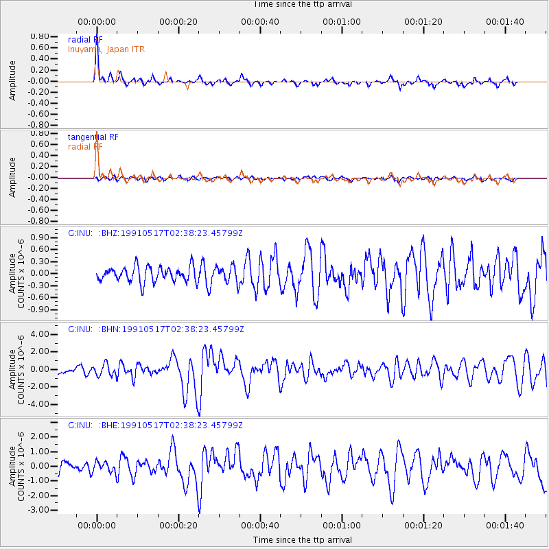
INU Inuyama, Japan - Earthquake Result Viewer
*The percent match for this event was below the threshold and hence no stack was calculated.
| Earthquake location: |
New Guinea, Papua New Guinea |
| Earthquake latitude/longitude: |
-4.4/142.6 |
| Earthquake time(UTC): |
1991/05/17 (137) 02:31:24 GMT |
| Earthquake Depth: |
47 km |
| Earthquake Magnitude: |
5.9 MB, 6.0 MS, 6.0 UNKNOWN |
| Earthquake Catalog/Contributor: |
WHDF/NEIC |
|
| Network: |
G GEOSCOPE |
| Station: |
INU Inuyama, Japan |
| Lat/Lon: |
35.35 N/137.03 E |
| Elevation: |
132 m |
|
| Distance: |
39.9 deg |
| Az: |
352.861 deg |
| Baz: |
171.281 deg |
| Ray Param: |
$rayparam |
*The percent match for this event was below the threshold and hence was not used in the summary stack. |
|
| Radial Match: |
77.67905 % |
| Radial Bump: |
278 |
| Transverse Match: |
44.78641 % |
| Transverse Bump: |
400 |
| SOD ConfigId: |
4480 |
| Insert Time: |
2010-02-26 23:25:01.051 +0000 |
| GWidth: |
2.5 |
| Max Bumps: |
400 |
| Tol: |
0.001 |
|
Signal To Noise
| Channel | StoN | STA | LTA |
| G:INU: :BHN:19910517T02:38:23.45799Z | 1.9769486 | 6.712517E-7 | 3.395393E-7 |
| G:INU: :BHE:19910517T02:38:23.45799Z | 1.0243427 | 3.4169406E-7 | 3.3357398E-7 |
| G:INU: :BHZ:19910517T02:38:23.45799Z | 1.1146302 | 2.0625289E-7 | 1.8504154E-7 |
| Arrivals |
| Ps | |
| PpPs | |
| PsPs/PpSs | |


