You are here: Home > Network List > G - GEOSCOPE Stations List
> Station INU Inuyama, Japan > Earthquake Result Viewer
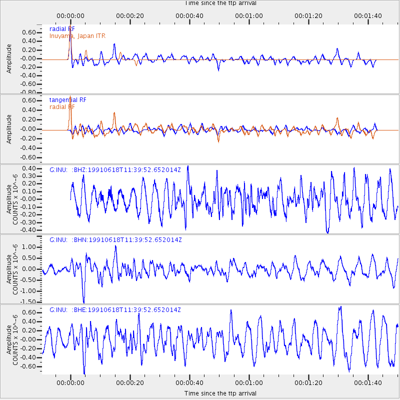
INU Inuyama, Japan - Earthquake Result Viewer
*The percent match for this event was below the threshold and hence no stack was calculated.
| Earthquake location: |
E. Caroline Islands, Micronesia |
| Earthquake latitude/longitude: |
0.1/149.3 |
| Earthquake time(UTC): |
1991/06/18 (169) 11:33:18 GMT |
| Earthquake Depth: |
38 km |
| Earthquake Magnitude: |
5.6 MB, 5.3 MS, 5.8 UNKNOWN |
| Earthquake Catalog/Contributor: |
WHDF/NEIC |
|
| Network: |
G GEOSCOPE |
| Station: |
INU Inuyama, Japan |
| Lat/Lon: |
35.35 N/137.03 E |
| Elevation: |
132 m |
|
| Distance: |
36.9 deg |
| Az: |
343.189 deg |
| Baz: |
159.281 deg |
| Ray Param: |
$rayparam |
*The percent match for this event was below the threshold and hence was not used in the summary stack. |
|
| Radial Match: |
59.227646 % |
| Radial Bump: |
397 |
| Transverse Match: |
44.71408 % |
| Transverse Bump: |
400 |
| SOD ConfigId: |
4480 |
| Insert Time: |
2010-02-26 23:25:01.903 +0000 |
| GWidth: |
2.5 |
| Max Bumps: |
400 |
| Tol: |
0.001 |
|
Signal To Noise
| Channel | StoN | STA | LTA |
| G:INU: :BHN:19910618T11:39:52.652014Z | 4.409213 | 5.3967636E-7 | 1.2239744E-7 |
| G:INU: :BHE:19910618T11:39:52.652014Z | 1.8762323 | 2.92311E-7 | 1.5579681E-7 |
| G:INU: :BHZ:19910618T11:39:52.652014Z | 1.413969 | 1.8807724E-7 | 1.3301369E-7 |
| Arrivals |
| Ps | |
| PpPs | |
| PsPs/PpSs | |


