You are here: Home > Network List > TA - USArray Transportable Network (new EarthScope stations) Stations List
> Station J32A Parkston, SD, USA > Earthquake Result Viewer
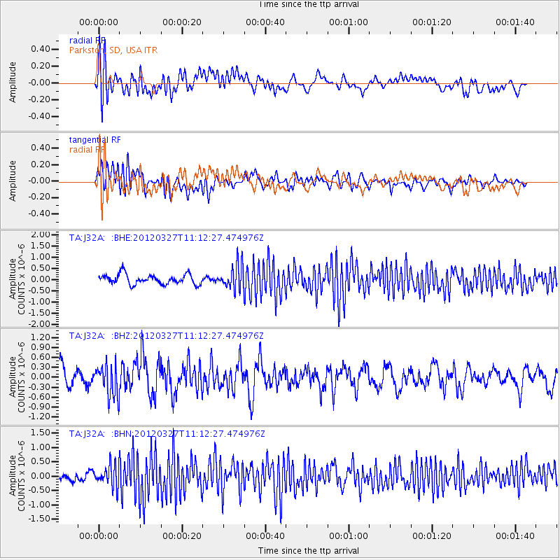
J32A Parkston, SD, USA - Earthquake Result Viewer
*The percent match for this event was below the threshold and hence no stack was calculated.
| Earthquake location: |
Near East Coast Of Honshu, Japan |
| Earthquake latitude/longitude: |
39.9/142.0 |
| Earthquake time(UTC): |
2012/03/27 (087) 11:00:44 GMT |
| Earthquake Depth: |
15 km |
| Earthquake Magnitude: |
6.0 MB, 5.7 MS, 6.1 MW, 5.9 MW |
| Earthquake Catalog/Contributor: |
WHDF/NEIC |
|
| Network: |
TA USArray Transportable Network (new EarthScope stations) |
| Station: |
J32A Parkston, SD, USA |
| Lat/Lon: |
43.37 N/97.85 W |
| Elevation: |
399 m |
|
| Distance: |
81.1 deg |
| Az: |
39.67 deg |
| Baz: |
317.635 deg |
| Ray Param: |
$rayparam |
*The percent match for this event was below the threshold and hence was not used in the summary stack. |
|
| Radial Match: |
70.10746 % |
| Radial Bump: |
400 |
| Transverse Match: |
61.067627 % |
| Transverse Bump: |
400 |
| SOD ConfigId: |
440406 |
| Insert Time: |
2012-06-08 07:47:41.161 +0000 |
| GWidth: |
2.5 |
| Max Bumps: |
400 |
| Tol: |
0.001 |
|
Signal To Noise
| Channel | StoN | STA | LTA |
| TA:J32A: :BHZ:20120327T11:12:27.474976Z | 1.6790032 | 4.8507496E-7 | 2.889065E-7 |
| TA:J32A: :BHN:20120327T11:12:27.474976Z | 1.8540056 | 3.7938682E-7 | 2.046309E-7 |
| TA:J32A: :BHE:20120327T11:12:27.474976Z | 2.5039713 | 5.5727816E-7 | 2.2255772E-7 |
| Arrivals |
| Ps | |
| PpPs | |
| PsPs/PpSs | |


