You are here: Home > Network List > YB13 - Continental Dynamics/Cent. Anatolian Tectonics:Surface to Mantle Dynamics During Stations List
> Station AT05 Ormanici,Malatya,Turkey > Earthquake Result Viewer
AT05 Ormanici,Malatya,Turkey - Earthquake Result Viewer
| Earthquake location: |
Near S. Coast Of Honshu, Japan |
| Earthquake latitude/longitude: |
34.9/139.3 |
| Earthquake time(UTC): |
2014/05/04 (124) 20:18:25 GMT |
| Earthquake Depth: |
156 km |
| Earthquake Magnitude: |
5.8 MB |
| Earthquake Catalog/Contributor: |
NEIC PDE/NEIC COMCAT |
|
| Network: |
YB Continental Dynamics/Cent. Anatolian Tectonics:Surface to Mantle Dynamics During |
| Station: |
AT05 Ormanici,Malatya,Turkey |
| Lat/Lon: |
38.22 N/38.79 E |
| Elevation: |
851 m |
|
| Distance: |
76.5 deg |
| Az: |
307.224 deg |
| Baz: |
56.198 deg |
| Ray Param: |
0.050533228 |
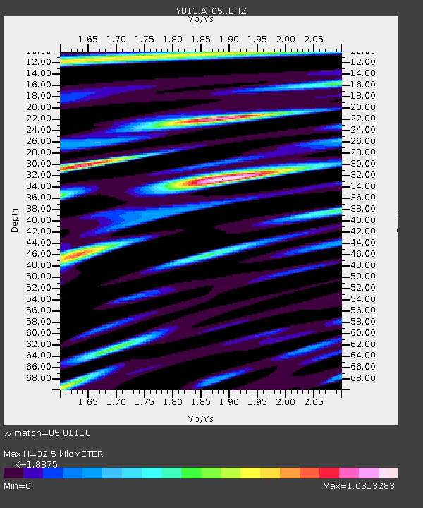
| Estimated Moho Depth: |
32.5 km |
| Estimated Crust Vp/Vs: |
1.89 |
| Assumed Crust Vp: |
6.35 km/s |
| Estimated Crust Vs: |
3.364 km/s |
| Estimated Crust Poisson's Ratio: |
0.30 |
|
| Radial Match: |
85.81118 % |
| Radial Bump: |
400 |
| Transverse Match: |
82.87602 % |
| Transverse Bump: |
400 |
| SOD ConfigId: |
3390531 |
| Insert Time: |
2019-04-11 17:12:55.119 +0000 |
| GWidth: |
2.5 |
| Max Bumps: |
400 |
| Tol: |
0.001 |
|

Signal To Noise
| Channel | StoN | STA | LTA |
| YB:AT05: :BHZ:20140504T20:29:26.660029Z | 13.807395 | 1.0753876E-6 | 7.78849E-8 |
| YB:AT05: :BHN:20140504T20:29:26.660029Z | 2.5032988 | 1.7407027E-7 | 6.9536355E-8 |
| YB:AT05: :BHE:20140504T20:29:26.660029Z | 5.4043226 | 3.271239E-7 | 6.053005E-8 |
| Arrivals |
| Ps | 4.7 SECOND |
| PpPs | 14 SECOND |
| PsPs/PpSs | 19 SECOND |


