You are here: Home > Network List > TA - USArray Transportable Network (new EarthScope stations) Stations List
> Station N39A Derby Farms, Drakesville, IA, USA > Earthquake Result Viewer
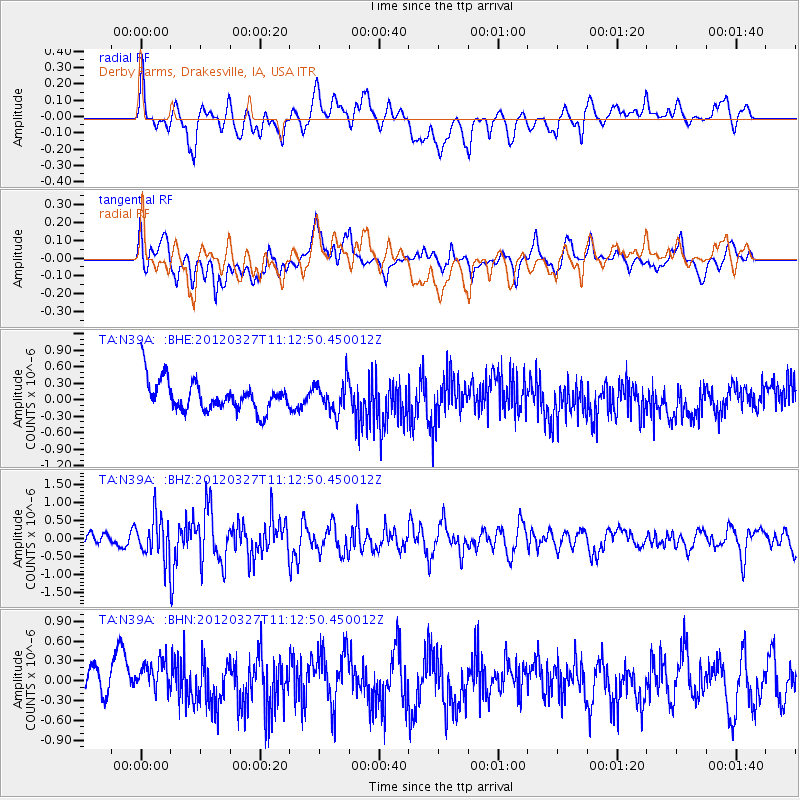
N39A Derby Farms, Drakesville, IA, USA - Earthquake Result Viewer
*The percent match for this event was below the threshold and hence no stack was calculated.
| Earthquake location: |
Near East Coast Of Honshu, Japan |
| Earthquake latitude/longitude: |
39.9/142.0 |
| Earthquake time(UTC): |
2012/03/27 (087) 11:00:44 GMT |
| Earthquake Depth: |
15 km |
| Earthquake Magnitude: |
6.0 MB, 5.7 MS, 6.1 MW, 5.9 MW |
| Earthquake Catalog/Contributor: |
WHDF/NEIC |
|
| Network: |
TA USArray Transportable Network (new EarthScope stations) |
| Station: |
N39A Derby Farms, Drakesville, IA, USA |
| Lat/Lon: |
40.88 N/92.50 W |
| Elevation: |
260 m |
|
| Distance: |
85.6 deg |
| Az: |
38.267 deg |
| Baz: |
321.046 deg |
| Ray Param: |
$rayparam |
*The percent match for this event was below the threshold and hence was not used in the summary stack. |
|
| Radial Match: |
64.174324 % |
| Radial Bump: |
400 |
| Transverse Match: |
56.56613 % |
| Transverse Bump: |
400 |
| SOD ConfigId: |
440406 |
| Insert Time: |
2012-06-08 07:51:39.241 +0000 |
| GWidth: |
2.5 |
| Max Bumps: |
400 |
| Tol: |
0.001 |
|
Signal To Noise
| Channel | StoN | STA | LTA |
| TA:N39A: :BHZ:20120327T11:12:50.450012Z | 1.8016723 | 5.623994E-7 | 3.121541E-7 |
| TA:N39A: :BHN:20120327T11:12:50.450012Z | 1.159139 | 3.3345057E-7 | 2.876709E-7 |
| TA:N39A: :BHE:20120327T11:12:50.450012Z | 1.0041928 | 2.7498405E-7 | 2.7383592E-7 |
| Arrivals |
| Ps | |
| PpPs | |
| PsPs/PpSs | |


