You are here: Home > Network List > YB13 - Continental Dynamics/Cent. Anatolian Tectonics:Surface to Mantle Dynamics During Stations List
> Station AT32 Orhanli,Nigde,Turkey > Earthquake Result Viewer
AT32 Orhanli,Nigde,Turkey - Earthquake Result Viewer
| Earthquake location: |
Near S. Coast Of Honshu, Japan |
| Earthquake latitude/longitude: |
34.9/139.3 |
| Earthquake time(UTC): |
2014/05/04 (124) 20:18:25 GMT |
| Earthquake Depth: |
156 km |
| Earthquake Magnitude: |
5.8 MB |
| Earthquake Catalog/Contributor: |
NEIC PDE/NEIC COMCAT |
|
| Network: |
YB Continental Dynamics/Cent. Anatolian Tectonics:Surface to Mantle Dynamics During |
| Station: |
AT32 Orhanli,Nigde,Turkey |
| Lat/Lon: |
38.30 N/34.89 E |
| Elevation: |
1504 m |
|
| Distance: |
79.0 deg |
| Az: |
309.086 deg |
| Baz: |
54.183 deg |
| Ray Param: |
0.048862036 |
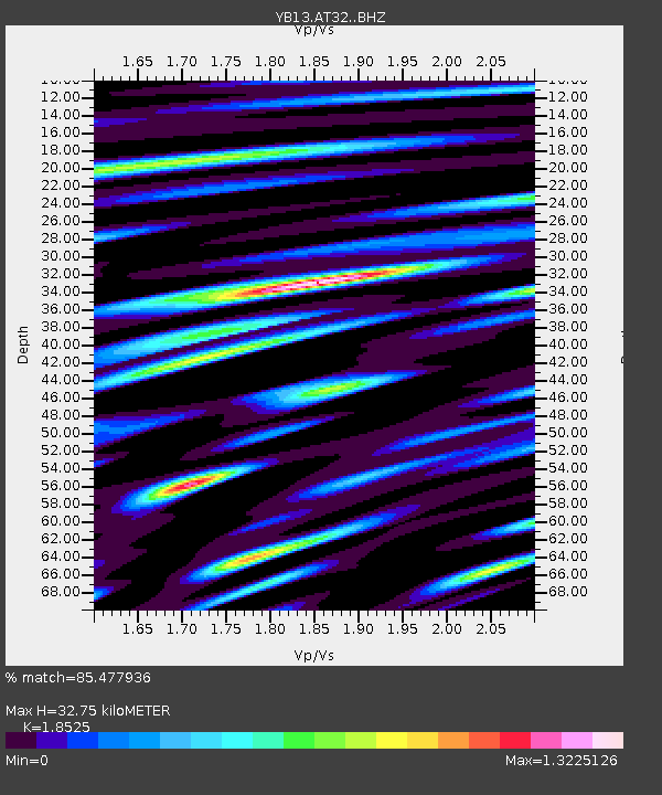
| Estimated Moho Depth: |
32.75 km |
| Estimated Crust Vp/Vs: |
1.85 |
| Assumed Crust Vp: |
6.35 km/s |
| Estimated Crust Vs: |
3.428 km/s |
| Estimated Crust Poisson's Ratio: |
0.29 |
|
| Radial Match: |
85.477936 % |
| Radial Bump: |
400 |
| Transverse Match: |
78.505974 % |
| Transverse Bump: |
400 |
| SOD ConfigId: |
3390531 |
| Insert Time: |
2019-04-11 17:13:13.581 +0000 |
| GWidth: |
2.5 |
| Max Bumps: |
400 |
| Tol: |
0.001 |
|

Signal To Noise
| Channel | StoN | STA | LTA |
| YB:AT32: :BHZ:20140504T20:29:40.299983Z | 18.279043 | 9.3084446E-7 | 5.0924136E-8 |
| YB:AT32: :BHN:20140504T20:29:40.299983Z | 10.465649 | 3.5891614E-7 | 3.4294686E-8 |
| YB:AT32: :BHE:20140504T20:29:40.299983Z | 7.7190876 | 3.3521303E-7 | 4.342651E-8 |
| Arrivals |
| Ps | 4.5 SECOND |
| PpPs | 14 SECOND |
| PsPs/PpSs | 19 SECOND |


