You are here: Home > Network List > TA - USArray Transportable Network (new EarthScope stations) Stations List
> Station T42A Van Buren, MO, USA > Earthquake Result Viewer
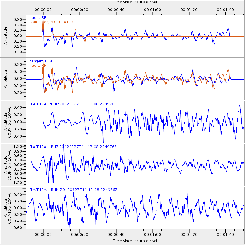
T42A Van Buren, MO, USA - Earthquake Result Viewer
*The percent match for this event was below the threshold and hence no stack was calculated.
| Earthquake location: |
Near East Coast Of Honshu, Japan |
| Earthquake latitude/longitude: |
39.9/142.0 |
| Earthquake time(UTC): |
2012/03/27 (087) 11:00:44 GMT |
| Earthquake Depth: |
15 km |
| Earthquake Magnitude: |
6.0 MB, 5.7 MS, 6.1 MW, 5.9 MW |
| Earthquake Catalog/Contributor: |
WHDF/NEIC |
|
| Network: |
TA USArray Transportable Network (new EarthScope stations) |
| Station: |
T42A Van Buren, MO, USA |
| Lat/Lon: |
37.03 N/91.09 W |
| Elevation: |
162 m |
|
| Distance: |
89.3 deg |
| Az: |
39.799 deg |
| Baz: |
321.999 deg |
| Ray Param: |
$rayparam |
*The percent match for this event was below the threshold and hence was not used in the summary stack. |
|
| Radial Match: |
65.25533 % |
| Radial Bump: |
400 |
| Transverse Match: |
69.84382 % |
| Transverse Bump: |
400 |
| SOD ConfigId: |
440406 |
| Insert Time: |
2012-06-08 07:57:25.907 +0000 |
| GWidth: |
2.5 |
| Max Bumps: |
400 |
| Tol: |
0.001 |
|
Signal To Noise
| Channel | StoN | STA | LTA |
| TA:T42A: :BHZ:20120327T11:13:08.224976Z | 3.1490872 | 4.789615E-7 | 1.5209535E-7 |
| TA:T42A: :BHN:20120327T11:13:08.224976Z | 0.9563265 | 1.5181277E-7 | 1.5874575E-7 |
| TA:T42A: :BHE:20120327T11:13:08.224976Z | 1.6921132 | 2.1526743E-7 | 1.2721812E-7 |
| Arrivals |
| Ps | |
| PpPs | |
| PsPs/PpSs | |


