You are here: Home > Network List > TA - USArray Transportable Network (new EarthScope stations) Stations List
> Station 435B Jarrell, TX, USA > Earthquake Result Viewer
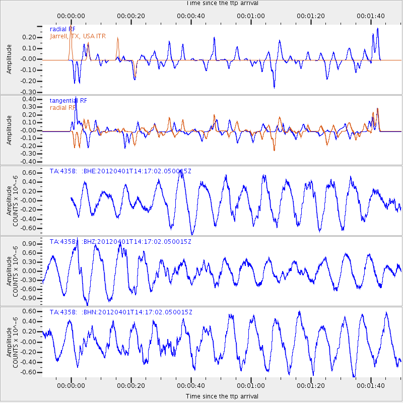
435B Jarrell, TX, USA - Earthquake Result Viewer
*The percent match for this event was below the threshold and hence no stack was calculated.
| Earthquake location: |
Eastern Honshu, Japan |
| Earthquake latitude/longitude: |
37.1/141.0 |
| Earthquake time(UTC): |
2012/04/01 (092) 14:04:24 GMT |
| Earthquake Depth: |
48 km |
| Earthquake Magnitude: |
5.8 MB, 5.2 MS, 5.7 MW, 5.7 MW |
| Earthquake Catalog/Contributor: |
WHDF/NEIC |
|
| Network: |
TA USArray Transportable Network (new EarthScope stations) |
| Station: |
435B Jarrell, TX, USA |
| Lat/Lon: |
30.78 N/97.58 W |
| Elevation: |
248 m |
|
| Distance: |
93.0 deg |
| Az: |
47.321 deg |
| Baz: |
316.935 deg |
| Ray Param: |
$rayparam |
*The percent match for this event was below the threshold and hence was not used in the summary stack. |
|
| Radial Match: |
78.282326 % |
| Radial Bump: |
400 |
| Transverse Match: |
84.42415 % |
| Transverse Bump: |
388 |
| SOD ConfigId: |
445498 |
| Insert Time: |
2012-06-23 03:51:10.423 +0000 |
| GWidth: |
2.5 |
| Max Bumps: |
400 |
| Tol: |
0.001 |
|
Signal To Noise
| Channel | StoN | STA | LTA |
| TA:435B: :BHZ:20120401T14:17:02.050015Z | 3.3459272 | 5.994038E-7 | 1.791443E-7 |
| TA:435B: :BHN:20120401T14:17:02.050015Z | 1.7212139 | 2.8574541E-7 | 1.6601389E-7 |
| TA:435B: :BHE:20120401T14:17:02.050015Z | 1.8162304 | 3.452127E-7 | 1.9007098E-7 |
| Arrivals |
| Ps | |
| PpPs | |
| PsPs/PpSs | |


