You are here: Home > Network List > TA - USArray Transportable Network (new EarthScope stations) Stations List
> Station P37A Lathrop, MO, USA > Earthquake Result Viewer
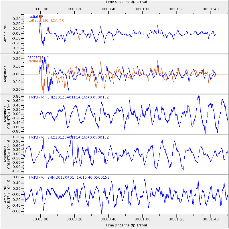
P37A Lathrop, MO, USA - Earthquake Result Viewer
*The percent match for this event was below the threshold and hence no stack was calculated.
| Earthquake location: |
Eastern Honshu, Japan |
| Earthquake latitude/longitude: |
37.1/141.0 |
| Earthquake time(UTC): |
2012/04/01 (092) 14:04:24 GMT |
| Earthquake Depth: |
48 km |
| Earthquake Magnitude: |
5.8 MB, 5.2 MS, 5.7 MW, 5.7 MW |
| Earthquake Catalog/Contributor: |
WHDF/NEIC |
|
| Network: |
TA USArray Transportable Network (new EarthScope stations) |
| Station: |
P37A Lathrop, MO, USA |
| Lat/Lon: |
39.59 N/94.35 W |
| Elevation: |
300 m |
|
| Distance: |
88.3 deg |
| Az: |
39.467 deg |
| Baz: |
318.888 deg |
| Ray Param: |
$rayparam |
*The percent match for this event was below the threshold and hence was not used in the summary stack. |
|
| Radial Match: |
65.25926 % |
| Radial Bump: |
400 |
| Transverse Match: |
80.12055 % |
| Transverse Bump: |
400 |
| SOD ConfigId: |
445498 |
| Insert Time: |
2012-06-23 03:57:01.701 +0000 |
| GWidth: |
2.5 |
| Max Bumps: |
400 |
| Tol: |
0.001 |
|
Signal To Noise
| Channel | StoN | STA | LTA |
| TA:P37A: :BHZ:20120401T14:16:40.050015Z | 1.6682144 | 5.0918874E-7 | 3.052298E-7 |
| TA:P37A: :BHN:20120401T14:16:40.050015Z | 1.3741329 | 2.417414E-7 | 1.7592288E-7 |
| TA:P37A: :BHE:20120401T14:16:40.050015Z | 1.2550051 | 3.0338833E-7 | 2.417427E-7 |
| Arrivals |
| Ps | |
| PpPs | |
| PsPs/PpSs | |


