You are here: Home > Network List > G - GEOSCOPE Stations List
> Station INU Inuyama, Japan > Earthquake Result Viewer
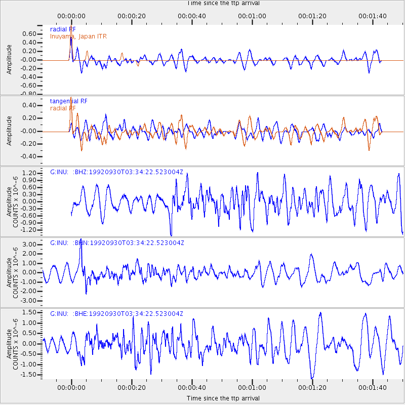
INU Inuyama, Japan - Earthquake Result Viewer
*The percent match for this event was below the threshold and hence no stack was calculated.
| Earthquake location: |
Andreanof Islands, Aleutian Is. |
| Earthquake latitude/longitude: |
51.4/-178.6 |
| Earthquake time(UTC): |
1992/09/30 (274) 03:28:00 GMT |
| Earthquake Depth: |
33 km |
| Earthquake Magnitude: |
5.9 MB, 5.6 MS, 5.9 UNKNOWN, 5.9 ML |
| Earthquake Catalog/Contributor: |
WHDF/NEIC |
|
| Network: |
G GEOSCOPE |
| Station: |
INU Inuyama, Japan |
| Lat/Lon: |
35.35 N/137.03 E |
| Elevation: |
132 m |
|
| Distance: |
35.4 deg |
| Az: |
260.567 deg |
| Baz: |
49.086 deg |
| Ray Param: |
$rayparam |
*The percent match for this event was below the threshold and hence was not used in the summary stack. |
|
| Radial Match: |
61.88685 % |
| Radial Bump: |
400 |
| Transverse Match: |
63.56412 % |
| Transverse Bump: |
400 |
| SOD ConfigId: |
4480 |
| Insert Time: |
2010-02-26 23:25:33.541 +0000 |
| GWidth: |
2.5 |
| Max Bumps: |
400 |
| Tol: |
0.001 |
|
Signal To Noise
| Channel | StoN | STA | LTA |
| G:INU: :BHN:19920930T03:34:22.523004Z | 2.327075 | 1.2807543E-6 | 5.503708E-7 |
| G:INU: :BHE:19920930T03:34:22.523004Z | 1.2138861 | 5.113225E-7 | 4.2122772E-7 |
| G:INU: :BHZ:19920930T03:34:22.523004Z | 1.4393969 | 5.224883E-7 | 3.629911E-7 |
| Arrivals |
| Ps | |
| PpPs | |
| PsPs/PpSs | |


