You are here: Home > Network List > G - GEOSCOPE Stations List
> Station INU Inuyama, Japan > Earthquake Result Viewer
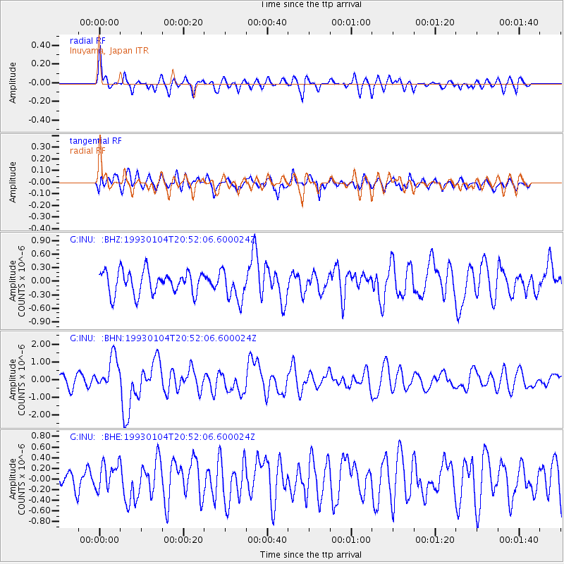
INU Inuyama, Japan - Earthquake Result Viewer
*The percent match for this event was below the threshold and hence no stack was calculated.
| Earthquake location: |
Tonga Islands |
| Earthquake latitude/longitude: |
-22.0/-174.9 |
| Earthquake time(UTC): |
1993/01/04 (004) 20:41:11 GMT |
| Earthquake Depth: |
33 km |
| Earthquake Magnitude: |
5.6 MB, 6.3 MS |
| Earthquake Catalog/Contributor: |
WHDF/NEIC |
|
| Network: |
G GEOSCOPE |
| Station: |
INU Inuyama, Japan |
| Lat/Lon: |
35.35 N/137.03 E |
| Elevation: |
132 m |
|
| Distance: |
73.0 deg |
| Az: |
320.499 deg |
| Baz: |
133.764 deg |
| Ray Param: |
$rayparam |
*The percent match for this event was below the threshold and hence was not used in the summary stack. |
|
| Radial Match: |
68.97479 % |
| Radial Bump: |
400 |
| Transverse Match: |
66.25373 % |
| Transverse Bump: |
400 |
| SOD ConfigId: |
4480 |
| Insert Time: |
2010-02-26 23:25:47.924 +0000 |
| GWidth: |
2.5 |
| Max Bumps: |
400 |
| Tol: |
0.001 |
|
Signal To Noise
| Channel | StoN | STA | LTA |
| G:INU: :BHN:19930104T20:52:06.600024Z | 3.155301 | 9.633583E-7 | 3.0531422E-7 |
| G:INU: :BHE:19930104T20:52:06.600024Z | 1.2615949 | 2.551084E-7 | 2.0221104E-7 |
| G:INU: :BHZ:19930104T20:52:06.600024Z | 1.3680335 | 3.4400657E-7 | 2.5146062E-7 |
| Arrivals |
| Ps | |
| PpPs | |
| PsPs/PpSs | |


