You are here: Home > Network List > TA - USArray Transportable Network (new EarthScope stations) Stations List
> Station P56A Dayton Farm, Ripley, WV, USA > Earthquake Result Viewer
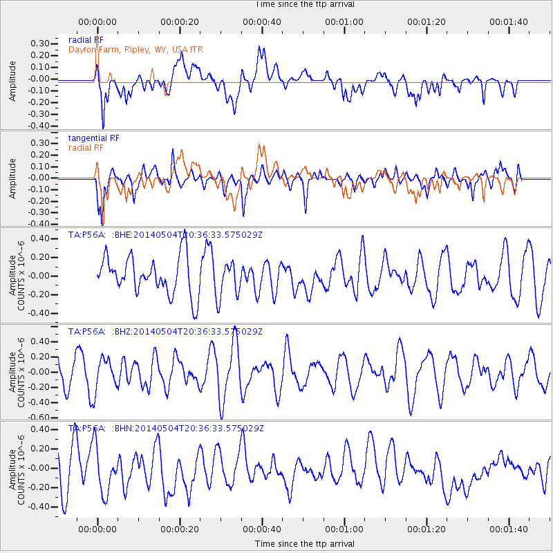
P56A Dayton Farm, Ripley, WV, USA - Earthquake Result Viewer
*The percent match for this event was below the threshold and hence no stack was calculated.
| Earthquake location: |
Kyrgyzstan-Xinjiang Border Reg. |
| Earthquake latitude/longitude: |
40.7/77.8 |
| Earthquake time(UTC): |
2014/05/04 (124) 20:23:32 GMT |
| Earthquake Depth: |
17 km |
| Earthquake Magnitude: |
5.4 mb |
| Earthquake Catalog/Contributor: |
ISC/ISC |
|
| Network: |
TA USArray Transportable Network (new EarthScope stations) |
| Station: |
P56A Dayton Farm, Ripley, WV, USA |
| Lat/Lon: |
39.50 N/78.84 W |
| Elevation: |
249 m |
|
| Distance: |
97.4 deg |
| Az: |
341.952 deg |
| Baz: |
17.728 deg |
| Ray Param: |
$rayparam |
*The percent match for this event was below the threshold and hence was not used in the summary stack. |
|
| Radial Match: |
38.83902 % |
| Radial Bump: |
400 |
| Transverse Match: |
59.595695 % |
| Transverse Bump: |
400 |
| SOD ConfigId: |
3390531 |
| Insert Time: |
2019-04-11 17:18:29.559 +0000 |
| GWidth: |
2.5 |
| Max Bumps: |
400 |
| Tol: |
0.001 |
|
Signal To Noise
| Channel | StoN | STA | LTA |
| TA:P56A: :BHZ:20140504T20:36:33.575029Z | 0.82193756 | 1.9637903E-7 | 2.389221E-7 |
| TA:P56A: :BHN:20140504T20:36:33.575029Z | 1.1046336 | 2.6704242E-7 | 2.4174753E-7 |
| TA:P56A: :BHE:20140504T20:36:33.575029Z | 0.9567841 | 1.951917E-7 | 2.0400809E-7 |
| Arrivals |
| Ps | |
| PpPs | |
| PsPs/PpSs | |


