You are here: Home > Network List > G - GEOSCOPE Stations List
> Station INU Inuyama, Japan > Earthquake Result Viewer
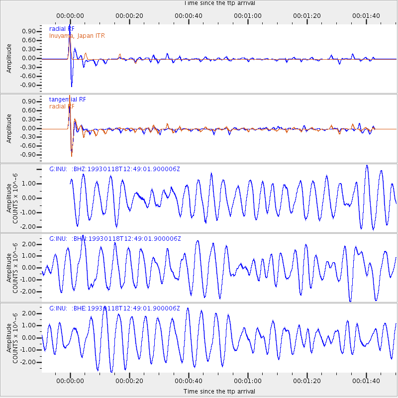
INU Inuyama, Japan - Earthquake Result Viewer
*The percent match for this event was below the threshold and hence no stack was calculated.
| Earthquake location: |
Xizang |
| Earthquake latitude/longitude: |
30.8/90.3 |
| Earthquake time(UTC): |
1993/01/18 (018) 12:42:07 GMT |
| Earthquake Depth: |
33 km |
| Earthquake Magnitude: |
5.7 MB, 5.7 MS |
| Earthquake Catalog/Contributor: |
WHDF/NEIC |
|
| Network: |
G GEOSCOPE |
| Station: |
INU Inuyama, Japan |
| Lat/Lon: |
35.35 N/137.03 E |
| Elevation: |
132 m |
|
| Distance: |
39.1 deg |
| Az: |
70.52 deg |
| Baz: |
276.94 deg |
| Ray Param: |
$rayparam |
*The percent match for this event was below the threshold and hence was not used in the summary stack. |
|
| Radial Match: |
58.499126 % |
| Radial Bump: |
400 |
| Transverse Match: |
68.53289 % |
| Transverse Bump: |
400 |
| SOD ConfigId: |
4480 |
| Insert Time: |
2010-02-26 23:25:52.092 +0000 |
| GWidth: |
2.5 |
| Max Bumps: |
400 |
| Tol: |
0.001 |
|
Signal To Noise
| Channel | StoN | STA | LTA |
| G:INU: :BHN:19930118T12:49:01.900006Z | 2.4081907 | 1.5663071E-6 | 6.5040825E-7 |
| G:INU: :BHE:19930118T12:49:01.900006Z | 1.1423768 | 7.699989E-7 | 6.740324E-7 |
| G:INU: :BHZ:19930118T12:49:01.900006Z | 0.47165236 | 4.5090093E-7 | 9.560026E-7 |
| Arrivals |
| Ps | |
| PpPs | |
| PsPs/PpSs | |


