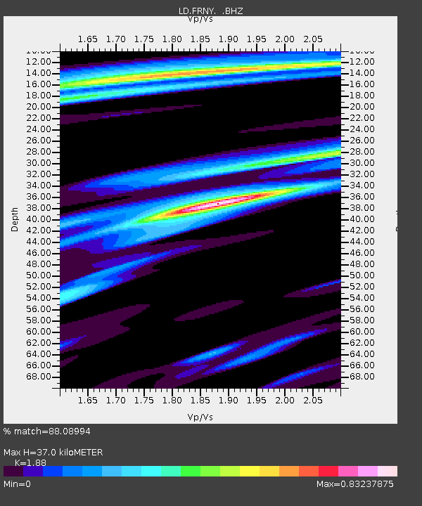
FRNY Flat Rock, Altona, NY - Earthquake Result Viewer

Earthquake location: Near Coast Of Guerrero, Mexico
Earthquake latitude/longitude: 16.4/-98.3
Earthquake time(UTC): 2012/04/02 (093) 17:36:42 GMT
Earthquake Depth: 9.0 km
Earthquake Magnitude: 5.8 MB, 5.9 MS, 6.0 MW, 6.0 MW
Earthquake Catalog/Contributor: WHDF/NEIC
Network: LD Lamont-Doherty Cooperative Seismographic Network
Station: FRNY Flat Rock, Altona, NY
Lat/Lon: 44.83 N/73.59 W
Elevation: 242 m
Distance: 35.2 deg
Az: 31.11 deg
Baz: 224.189 deg
Ray Param: 0.07736469
Estimated Moho Depth: 37.0 km
Estimated Crust Vp/Vs: 1.88
Assumed Crust Vp: 6.419 km/s
Estimated Crust Vs: 3.414 km/s
Estimated Crust Poisson's Ratio: 0.30
Radial Match: 88.08994 %
Radial Bump: 324
Transverse Match: 56.612858 %
Transverse Bump: 400
SOD ConfigId: 445498
Insert Time: 2012-06-23 04:37:24.737 +0000
GWidth: 2.5
Max Bumps: 400
Tol: 0.001

Signal To Noise

ChannelStoNSTALTA
LD:FRNY: :BHZ:20120402T17:43:05.394991Z7.23553661.6466275E-62.2757503E-7
LD:FRNY: :BHN:20120402T17:43:05.394991Z2.45999656.836664E-72.7791359E-7
LD:FRNY: :BHE:20120402T17:43:05.394991Z2.68220147.2798537E-72.714134E-7
Arrivals
Ps5.4 SECOND
PpPs15 SECOND
PsPs/PpSs21 SECOND