You are here: Home > Network List > G - GEOSCOPE Stations List
> Station INU Inuyama, Japan > Earthquake Result Viewer
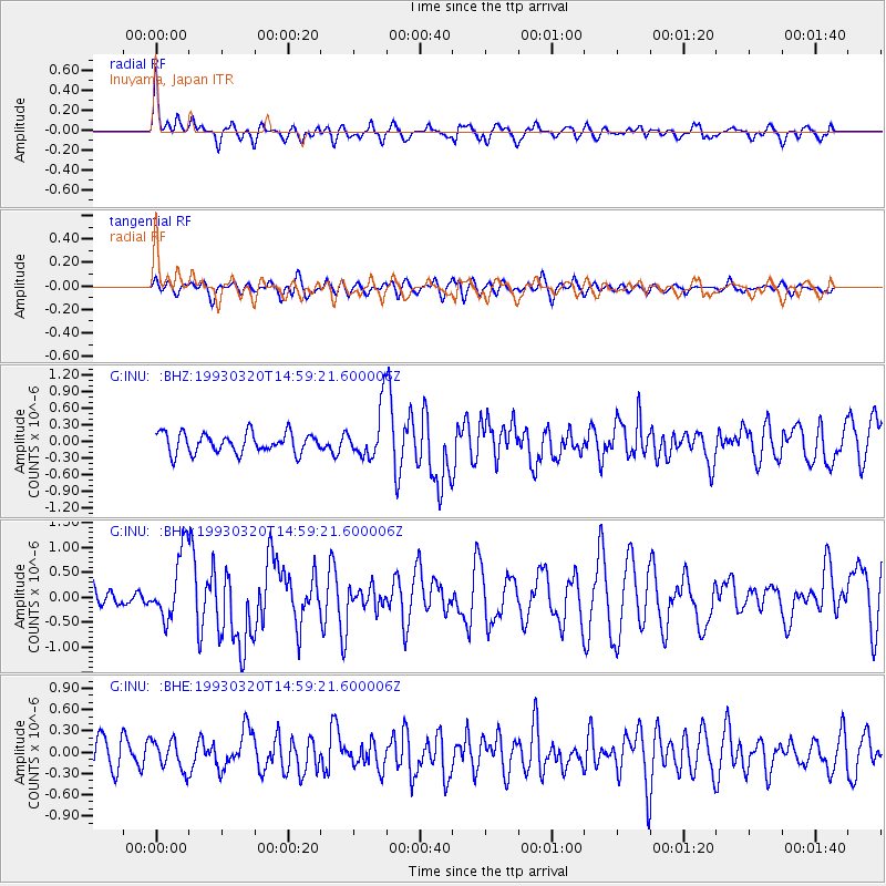
INU Inuyama, Japan - Earthquake Result Viewer
*The percent match for this event was below the threshold and hence no stack was calculated.
| Earthquake location: |
Xizang |
| Earthquake latitude/longitude: |
29.0/87.3 |
| Earthquake time(UTC): |
1993/03/20 (079) 14:52:01 GMT |
| Earthquake Depth: |
22 km |
| Earthquake Magnitude: |
5.9 MB, 6.0 MS |
| Earthquake Catalog/Contributor: |
WHDF/NEIC |
|
| Network: |
G GEOSCOPE |
| Station: |
INU Inuyama, Japan |
| Lat/Lon: |
35.35 N/137.03 E |
| Elevation: |
132 m |
|
| Distance: |
42.2 deg |
| Az: |
68.187 deg |
| Baz: |
275.843 deg |
| Ray Param: |
$rayparam |
*The percent match for this event was below the threshold and hence was not used in the summary stack. |
|
| Radial Match: |
73.99722 % |
| Radial Bump: |
400 |
| Transverse Match: |
55.418343 % |
| Transverse Bump: |
400 |
| SOD ConfigId: |
4480 |
| Insert Time: |
2010-02-26 23:26:02.427 +0000 |
| GWidth: |
2.5 |
| Max Bumps: |
400 |
| Tol: |
0.001 |
|
Signal To Noise
| Channel | StoN | STA | LTA |
| G:INU: :BHN:19930320T14:59:21.600006Z | 2.6090195 | 6.9491125E-7 | 2.6634956E-7 |
| G:INU: :BHE:19930320T14:59:21.600006Z | 1.162611 | 2.0756322E-7 | 1.7853196E-7 |
| G:INU: :BHZ:19930320T14:59:21.600006Z | 2.5427685 | 4.5867503E-7 | 1.8038409E-7 |
| Arrivals |
| Ps | |
| PpPs | |
| PsPs/PpSs | |


