You are here: Home > Network List > TA - USArray Transportable Network (new EarthScope stations) Stations List
> Station M04C Macdoel, CA, USA > Earthquake Result Viewer
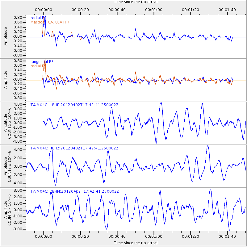
M04C Macdoel, CA, USA - Earthquake Result Viewer
*The percent match for this event was below the threshold and hence no stack was calculated.
| Earthquake location: |
Near Coast Of Guerrero, Mexico |
| Earthquake latitude/longitude: |
16.4/-98.3 |
| Earthquake time(UTC): |
2012/04/02 (093) 17:36:42 GMT |
| Earthquake Depth: |
9.0 km |
| Earthquake Magnitude: |
5.8 MB, 5.9 MS, 6.0 MW, 6.0 MW |
| Earthquake Catalog/Contributor: |
WHDF/NEIC |
|
| Network: |
TA USArray Transportable Network (new EarthScope stations) |
| Station: |
M04C Macdoel, CA, USA |
| Lat/Lon: |
41.78 N/121.84 W |
| Elevation: |
1391 m |
|
| Distance: |
32.4 deg |
| Az: |
326.135 deg |
| Baz: |
134.343 deg |
| Ray Param: |
$rayparam |
*The percent match for this event was below the threshold and hence was not used in the summary stack. |
|
| Radial Match: |
75.06053 % |
| Radial Bump: |
338 |
| Transverse Match: |
65.497444 % |
| Transverse Bump: |
400 |
| SOD ConfigId: |
445498 |
| Insert Time: |
2012-06-23 04:41:10.046 +0000 |
| GWidth: |
2.5 |
| Max Bumps: |
400 |
| Tol: |
0.001 |
|
Signal To Noise
| Channel | StoN | STA | LTA |
| TA:M04C: :BHZ:20120402T17:42:41.250002Z | 4.4692373 | 2.2016193E-6 | 4.926163E-7 |
| TA:M04C: :BHN:20120402T17:42:41.250002Z | 1.6621817 | 1.4371723E-6 | 8.6463007E-7 |
| TA:M04C: :BHE:20120402T17:42:41.250002Z | 2.0492437 | 1.4416261E-6 | 7.0349176E-7 |
| Arrivals |
| Ps | |
| PpPs | |
| PsPs/PpSs | |


