You are here: Home > Network List > TA - USArray Transportable Network (new EarthScope stations) Stations List
> Station G05D Wamic, OR, USA > Earthquake Result Viewer
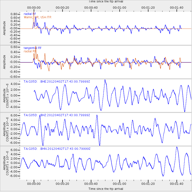
G05D Wamic, OR, USA - Earthquake Result Viewer
*The percent match for this event was below the threshold and hence no stack was calculated.
| Earthquake location: |
Near Coast Of Guerrero, Mexico |
| Earthquake latitude/longitude: |
16.4/-98.3 |
| Earthquake time(UTC): |
2012/04/02 (093) 17:36:42 GMT |
| Earthquake Depth: |
9.0 km |
| Earthquake Magnitude: |
5.8 MB, 5.9 MS, 6.0 MW, 6.0 MW |
| Earthquake Catalog/Contributor: |
WHDF/NEIC |
|
| Network: |
TA USArray Transportable Network (new EarthScope stations) |
| Station: |
G05D Wamic, OR, USA |
| Lat/Lon: |
45.24 N/121.32 W |
| Elevation: |
592 m |
|
| Distance: |
34.6 deg |
| Az: |
330.944 deg |
| Baz: |
138.713 deg |
| Ray Param: |
$rayparam |
*The percent match for this event was below the threshold and hence was not used in the summary stack. |
|
| Radial Match: |
71.82091 % |
| Radial Bump: |
255 |
| Transverse Match: |
46.970394 % |
| Transverse Bump: |
314 |
| SOD ConfigId: |
445498 |
| Insert Time: |
2012-06-23 04:41:49.655 +0000 |
| GWidth: |
2.5 |
| Max Bumps: |
400 |
| Tol: |
0.001 |
|
Signal To Noise
| Channel | StoN | STA | LTA |
| TA:G05D: :BHZ:20120402T17:43:00.79999Z | 2.3122857 | 2.708838E-6 | 1.1714981E-6 |
| TA:G05D: :BHN:20120402T17:43:00.79999Z | 0.80116606 | 9.920319E-7 | 1.2382351E-6 |
| TA:G05D: :BHE:20120402T17:43:00.79999Z | 0.56204224 | 1.1228698E-6 | 1.9978388E-6 |
| Arrivals |
| Ps | |
| PpPs | |
| PsPs/PpSs | |


