You are here: Home > Network List > G - GEOSCOPE Stations List
> Station INU Inuyama, Japan > Earthquake Result Viewer
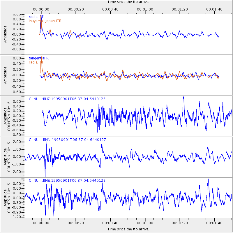
INU Inuyama, Japan - Earthquake Result Viewer
*The percent match for this event was below the threshold and hence no stack was calculated.
| Earthquake location: |
Minahassa Peninsula, Sulawesi |
| Earthquake latitude/longitude: |
0.0/123.2 |
| Earthquake time(UTC): |
1995/09/01 (244) 06:30:37 GMT |
| Earthquake Depth: |
163 km |
| Earthquake Magnitude: |
5.5 MB |
| Earthquake Catalog/Contributor: |
WHDF/NEIC |
|
| Network: |
G GEOSCOPE |
| Station: |
INU Inuyama, Japan |
| Lat/Lon: |
35.35 N/137.03 E |
| Elevation: |
132 m |
|
| Distance: |
37.4 deg |
| Az: |
18.685 deg |
| Baz: |
203.073 deg |
| Ray Param: |
$rayparam |
*The percent match for this event was below the threshold and hence was not used in the summary stack. |
|
| Radial Match: |
75.97365 % |
| Radial Bump: |
400 |
| Transverse Match: |
62.96368 % |
| Transverse Bump: |
400 |
| SOD ConfigId: |
4480 |
| Insert Time: |
2010-02-26 23:26:06.687 +0000 |
| GWidth: |
2.5 |
| Max Bumps: |
400 |
| Tol: |
0.001 |
|
Signal To Noise
| Channel | StoN | STA | LTA |
| G:INU: :BHN:19950901T06:37:04.644012Z | 3.7780676 | 7.266996E-7 | 1.923469E-7 |
| G:INU: :BHE:19950901T06:37:04.644012Z | 2.812193 | 3.9163447E-7 | 1.3926302E-7 |
| G:INU: :BHZ:19950901T06:37:04.644012Z | 1.4446797 | 2.5627364E-7 | 1.7739131E-7 |
| Arrivals |
| Ps | |
| PpPs | |
| PsPs/PpSs | |


