You are here: Home > Network List > TA - USArray Transportable Network (new EarthScope stations) Stations List
> Station L02D Cave Junction, OR, USA > Earthquake Result Viewer
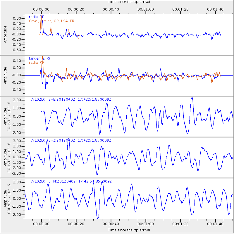
L02D Cave Junction, OR, USA - Earthquake Result Viewer
*The percent match for this event was below the threshold and hence no stack was calculated.
| Earthquake location: |
Near Coast Of Guerrero, Mexico |
| Earthquake latitude/longitude: |
16.4/-98.3 |
| Earthquake time(UTC): |
2012/04/02 (093) 17:36:42 GMT |
| Earthquake Depth: |
9.0 km |
| Earthquake Magnitude: |
5.8 MB, 5.9 MS, 6.0 MW, 6.0 MW |
| Earthquake Catalog/Contributor: |
WHDF/NEIC |
|
| Network: |
TA USArray Transportable Network (new EarthScope stations) |
| Station: |
L02D Cave Junction, OR, USA |
| Lat/Lon: |
42.16 N/123.60 W |
| Elevation: |
458 m |
|
| Distance: |
33.6 deg |
| Az: |
324.98 deg |
| Baz: |
132.2 deg |
| Ray Param: |
$rayparam |
*The percent match for this event was below the threshold and hence was not used in the summary stack. |
|
| Radial Match: |
56.65594 % |
| Radial Bump: |
335 |
| Transverse Match: |
58.266052 % |
| Transverse Bump: |
311 |
| SOD ConfigId: |
445498 |
| Insert Time: |
2012-06-23 04:42:03.107 +0000 |
| GWidth: |
2.5 |
| Max Bumps: |
400 |
| Tol: |
0.001 |
|
Signal To Noise
| Channel | StoN | STA | LTA |
| TA:L02D: :BHZ:20120402T17:42:51.850009Z | 2.661103 | 1.6348919E-6 | 6.1436623E-7 |
| TA:L02D: :BHN:20120402T17:42:51.850009Z | 1.6736913 | 1.0564752E-6 | 6.312247E-7 |
| TA:L02D: :BHE:20120402T17:42:51.850009Z | 1.3656275 | 9.96745E-7 | 7.298806E-7 |
| Arrivals |
| Ps | |
| PpPs | |
| PsPs/PpSs | |


