You are here: Home > Network List > G - GEOSCOPE Stations List
> Station INU Inuyama, Japan > Earthquake Result Viewer
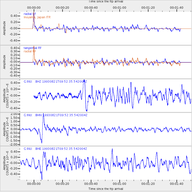
INU Inuyama, Japan - Earthquake Result Viewer
*The percent match for this event was below the threshold and hence no stack was calculated.
| Earthquake location: |
Fiji Islands Region |
| Earthquake latitude/longitude: |
-21.3/-178.1 |
| Earthquake time(UTC): |
1993/08/21 (233) 09:42:36 GMT |
| Earthquake Depth: |
434 km |
| Earthquake Magnitude: |
5.8 MB, 6.0 UNKNOWN |
| Earthquake Catalog/Contributor: |
WHDF/NEIC |
|
| Network: |
G GEOSCOPE |
| Station: |
INU Inuyama, Japan |
| Lat/Lon: |
35.35 N/137.03 E |
| Elevation: |
132 m |
|
| Distance: |
70.6 deg |
| Az: |
322.27 deg |
| Baz: |
135.719 deg |
| Ray Param: |
$rayparam |
*The percent match for this event was below the threshold and hence was not used in the summary stack. |
|
| Radial Match: |
73.2612 % |
| Radial Bump: |
399 |
| Transverse Match: |
72.64976 % |
| Transverse Bump: |
400 |
| SOD ConfigId: |
4480 |
| Insert Time: |
2010-02-26 23:26:11.690 +0000 |
| GWidth: |
2.5 |
| Max Bumps: |
400 |
| Tol: |
0.001 |
|
Signal To Noise
| Channel | StoN | STA | LTA |
| G:INU: :BHN:19930821T09:52:35.542004Z | 8.366288 | 4.3129873E-7 | 5.155198E-8 |
| G:INU: :BHE:19930821T09:52:35.542004Z | 2.1597905 | 1.5801692E-7 | 7.316308E-8 |
| G:INU: :BHZ:19930821T09:52:35.542004Z | 2.2808254 | 1.3201377E-7 | 5.7879824E-8 |
| Arrivals |
| Ps | |
| PpPs | |
| PsPs/PpSs | |


