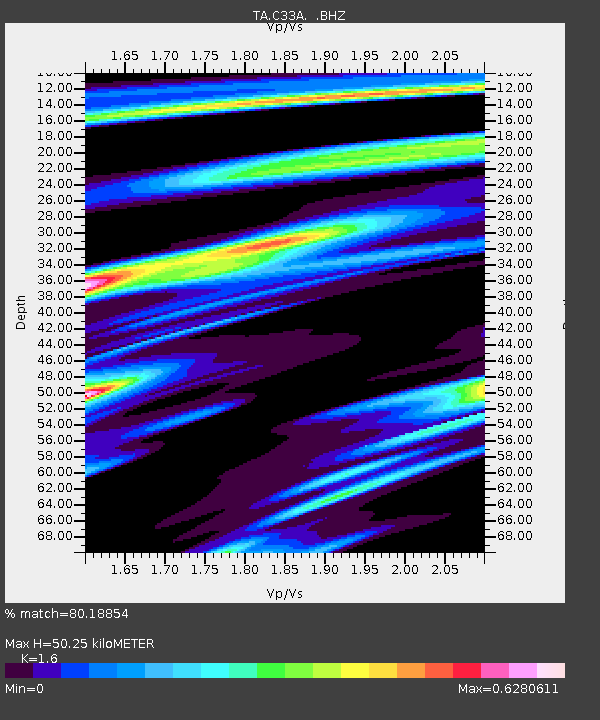
C33A Trail, MN, USA - Earthquake Result Viewer

Earthquake location: Near Coast Of Guerrero, Mexico
Earthquake latitude/longitude: 16.4/-98.3
Earthquake time(UTC): 2012/04/02 (093) 17:36:42 GMT
Earthquake Depth: 9.0 km
Earthquake Magnitude: 5.8 MB, 5.9 MS, 6.0 MW, 6.0 MW
Earthquake Catalog/Contributor: WHDF/NEIC
Network: TA USArray Transportable Network (new EarthScope stations)
Station: C33A Trail, MN, USA
Lat/Lon: 47.76 N/95.77 W
Elevation: 388 m
Distance: 31.3 deg
Az: 3.3 deg
Baz: 184.697 deg
Ray Param: 0.07909468
Estimated Moho Depth: 50.25 km
Estimated Crust Vp/Vs: 1.60
Assumed Crust Vp: 6.419 km/s
Estimated Crust Vs: 4.012 km/s
Estimated Crust Poisson's Ratio: 0.18
Radial Match: 80.18854 %
Radial Bump: 372
Transverse Match: 52.42784 %
Transverse Bump: 400
SOD ConfigId: 445498
Insert Time: 2012-06-23 04:44:13.788 +0000
GWidth: 2.5
Max Bumps: 400
Tol: 0.001

Signal To Noise

ChannelStoNSTALTA
TA:C33A: :BHZ:20120402T17:42:32.125002Z7.7142871.599541E-62.0734787E-7
TA:C33A: :BHN:20120402T17:42:32.125002Z5.7850651.2724162E-62.1994846E-7
TA:C33A: :BHE:20120402T17:42:32.125002Z2.18389963.080047E-71.4103428E-7
Arrivals
Ps5.1 SECOND
PpPs19 SECOND
PsPs/PpSs24 SECOND