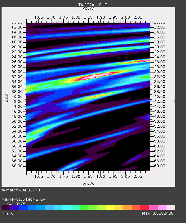
C37A Embarrass, MN, USA - Earthquake Result Viewer

Earthquake location: Near Coast Of Guerrero, Mexico
Earthquake latitude/longitude: 16.4/-98.3
Earthquake time(UTC): 2012/04/02 (093) 17:36:42 GMT
Earthquake Depth: 9.0 km
Earthquake Magnitude: 5.8 MB, 5.9 MS, 6.0 MW, 6.0 MW
Earthquake Catalog/Contributor: WHDF/NEIC
Network: TA USArray Transportable Network (new EarthScope stations)
Station: C37A Embarrass, MN, USA
Lat/Lon: 47.73 N/92.19 W
Elevation: 447 m
Distance: 31.7 deg
Az: 7.897 deg
Baz: 191.265 deg
Ray Param: 0.07898772
Estimated Moho Depth: 31.5 km
Estimated Crust Vp/Vs: 1.88
Assumed Crust Vp: 6.571 km/s
Estimated Crust Vs: 3.5 km/s
Estimated Crust Poisson's Ratio: 0.30
Radial Match: 84.81778 %
Radial Bump: 374
Transverse Match: 45.867542 %
Transverse Bump: 400
SOD ConfigId: 445498
Insert Time: 2012-06-23 04:45:20.415 +0000
GWidth: 2.5
Max Bumps: 400
Tol: 0.001

Signal To Noise

ChannelStoNSTALTA
TA:C37A: :BHZ:20120402T17:42:34.79999Z6.5253591.9329937E-62.9622794E-7
TA:C37A: :BHN:20120402T17:42:34.79999Z4.7226019.4723254E-72.0057433E-7
TA:C37A: :BHE:20120402T17:42:34.79999Z1.08804832.2392477E-72.0580407E-7
Arrivals
Ps4.6 SECOND
PpPs13 SECOND
PsPs/PpSs17 SECOND