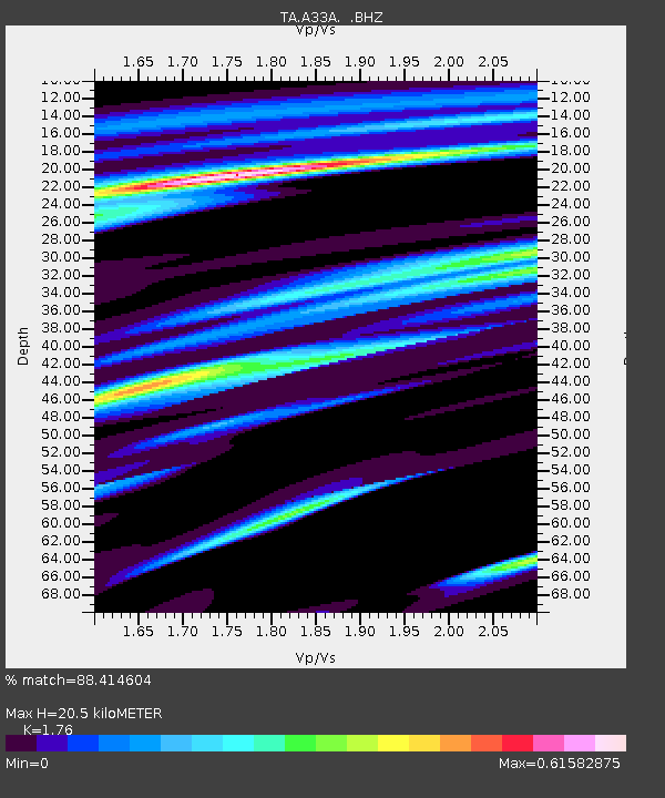
A33A Warroad, MN, USA - Earthquake Result Viewer
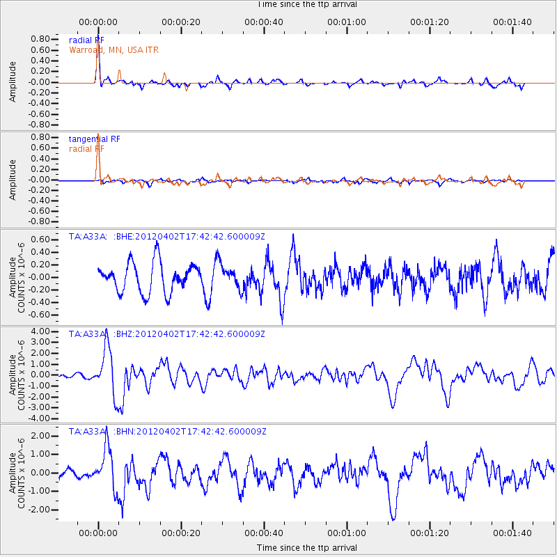
Earthquake location: Near Coast Of Guerrero, Mexico
Earthquake latitude/longitude: 16.4/-98.3
Earthquake time(UTC): 2012/04/02 (093) 17:36:42 GMT
Earthquake Depth: 9.0 km
Earthquake Magnitude: 5.8 MB, 5.9 MS, 6.0 MW, 6.0 MW
Earthquake Catalog/Contributor: WHDF/NEIC
Network: TA USArray Transportable Network (new EarthScope stations)
Station: A33A Warroad, MN, USA
Lat/Lon: 48.94 N/95.39 W
Elevation: 329 m
Distance: 32.5 deg
Az: 3.587 deg
Baz: 185.225 deg
Ray Param: 0.07860893
Estimated Moho Depth: 20.5 km
Estimated Crust Vp/Vs: 1.76
Assumed Crust Vp: 6.419 km/s
Estimated Crust Vs: 3.647 km/s
Estimated Crust Poisson's Ratio: 0.26
Radial Match: 88.414604 %
Radial Bump: 320
Transverse Match: 63.571575 %
Transverse Bump: 400
SOD ConfigId: 445498
Insert Time: 2012-06-23 04:45:38.300 +0000
GWidth: 2.5
Max Bumps: 400
Tol: 0.001

Signal To Noise

ChannelStoNSTALTA
TA:A33A: :BHZ:20120402T17:42:42.600009Z9.2191132.2580698E-62.4493352E-7
TA:A33A: :BHN:20120402T17:42:42.600009Z5.1321311.1763999E-62.292225E-7
TA:A33A: :BHE:20120402T17:42:42.600009Z0.78648531.812977E-72.305163E-7
Arrivals
Ps2.6 SECOND
PpPs8.1 SECOND
PsPs/PpSs11 SECOND