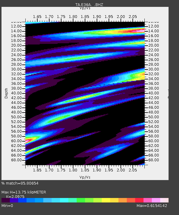
E36A McGregor, MN, USA - Earthquake Result Viewer
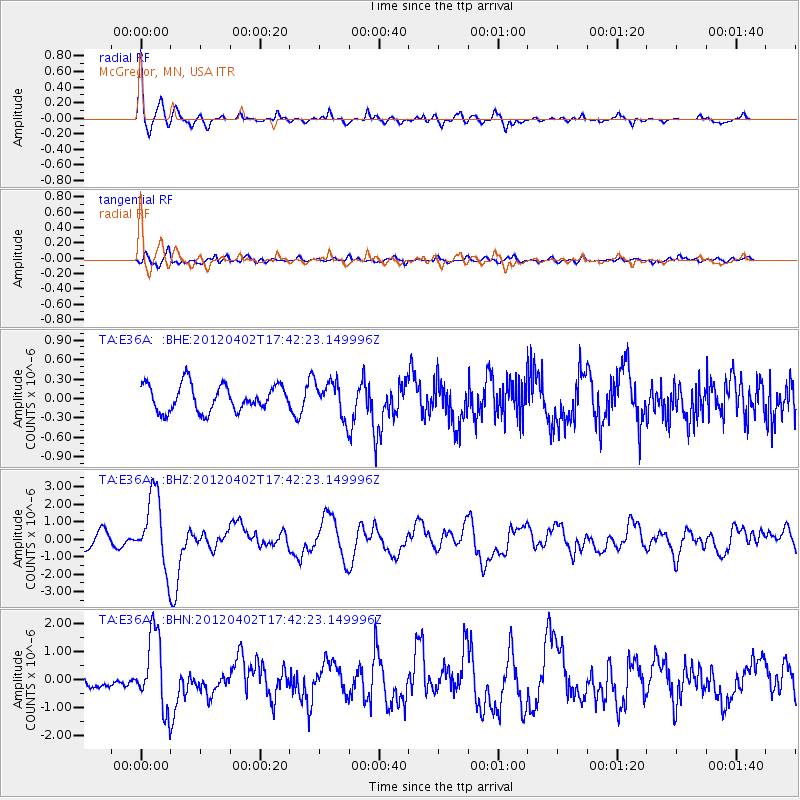
Earthquake location: Near Coast Of Guerrero, Mexico
Earthquake latitude/longitude: 16.4/-98.3
Earthquake time(UTC): 2012/04/02 (093) 17:36:42 GMT
Earthquake Depth: 9.0 km
Earthquake Magnitude: 5.8 MB, 5.9 MS, 6.0 MW, 6.0 MW
Earthquake Catalog/Contributor: WHDF/NEIC
Network: TA USArray Transportable Network (new EarthScope stations)
Station: E36A McGregor, MN, USA
Lat/Lon: 46.52 N/93.26 W
Elevation: 393 m
Distance: 30.3 deg
Az: 6.928 deg
Baz: 189.652 deg
Ray Param: 0.079361975
Estimated Moho Depth: 13.75 km
Estimated Crust Vp/Vs: 2.10
Assumed Crust Vp: 6.571 km/s
Estimated Crust Vs: 3.133 km/s
Estimated Crust Poisson's Ratio: 0.35
Radial Match: 85.80654 %
Radial Bump: 400
Transverse Match: 77.21815 %
Transverse Bump: 400
SOD ConfigId: 445498
Insert Time: 2012-06-23 04:45:51.154 +0000
GWidth: 2.5
Max Bumps: 400
Tol: 0.001

Signal To Noise

ChannelStoNSTALTA
TA:E36A: :BHZ:20120402T17:42:23.149996Z6.01967952.057504E-63.4179624E-7
TA:E36A: :BHN:20120402T17:42:23.149996Z7.8770911.3167527E-61.6716231E-7
TA:E36A: :BHE:20120402T17:42:23.149996Z1.34887862.7479567E-72.0372157E-7
Arrivals
Ps2.5 SECOND
PpPs6.0 SECOND
PsPs/PpSs8.5 SECOND