You are here: Home > Network List > G - GEOSCOPE Stations List
> Station INU Inuyama, Japan > Earthquake Result Viewer
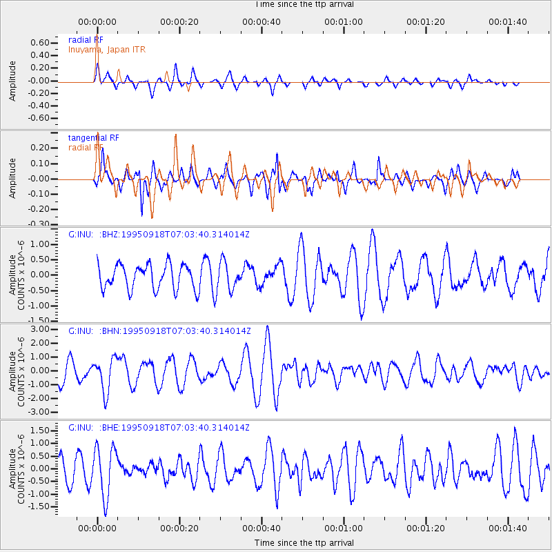
INU Inuyama, Japan - Earthquake Result Viewer
*The percent match for this event was below the threshold and hence no stack was calculated.
| Earthquake location: |
Banda Sea |
| Earthquake latitude/longitude: |
-6.9/128.9 |
| Earthquake time(UTC): |
1995/09/18 (261) 06:56:31 GMT |
| Earthquake Depth: |
180 km |
| Earthquake Magnitude: |
5.5 MB |
| Earthquake Catalog/Contributor: |
WHDF/NEIC |
|
| Network: |
G GEOSCOPE |
| Station: |
INU Inuyama, Japan |
| Lat/Lon: |
35.35 N/137.03 E |
| Elevation: |
132 m |
|
| Distance: |
42.8 deg |
| Az: |
9.808 deg |
| Baz: |
191.939 deg |
| Ray Param: |
$rayparam |
*The percent match for this event was below the threshold and hence was not used in the summary stack. |
|
| Radial Match: |
42.780685 % |
| Radial Bump: |
331 |
| Transverse Match: |
72.142426 % |
| Transverse Bump: |
335 |
| SOD ConfigId: |
4480 |
| Insert Time: |
2010-02-26 23:26:15.778 +0000 |
| GWidth: |
2.5 |
| Max Bumps: |
400 |
| Tol: |
0.001 |
|
Signal To Noise
| Channel | StoN | STA | LTA |
| G:INU: :BHN:19950918T07:03:40.314014Z | 1.8795016 | 1.2558107E-6 | 6.6816153E-7 |
| G:INU: :BHE:19950918T07:03:40.314014Z | 2.1725109 | 9.988568E-7 | 4.597707E-7 |
| G:INU: :BHZ:19950918T07:03:40.314014Z | 1.1113986 | 4.4222222E-7 | 3.9789705E-7 |
| Arrivals |
| Ps | |
| PpPs | |
| PsPs/PpSs | |


