You are here: Home > Network List > TA - USArray Transportable Network (new EarthScope stations) Stations List
> Station E38A The Farm, Brule, WI, USA > Earthquake Result Viewer
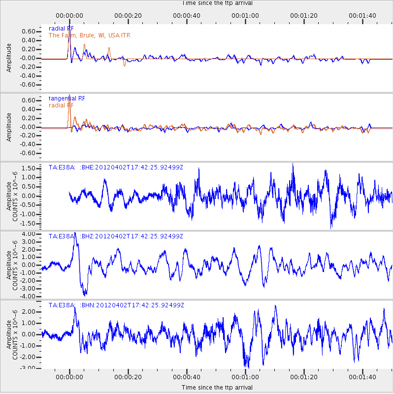
E38A The Farm, Brule, WI, USA - Earthquake Result Viewer
*The percent match for this event was below the threshold and hence no stack was calculated.
| Earthquake location: |
Near Coast Of Guerrero, Mexico |
| Earthquake latitude/longitude: |
16.4/-98.3 |
| Earthquake time(UTC): |
2012/04/02 (093) 17:36:42 GMT |
| Earthquake Depth: |
9.0 km |
| Earthquake Magnitude: |
5.8 MB, 5.9 MS, 6.0 MW, 6.0 MW |
| Earthquake Catalog/Contributor: |
WHDF/NEIC |
|
| Network: |
TA USArray Transportable Network (new EarthScope stations) |
| Station: |
E38A The Farm, Brule, WI, USA |
| Lat/Lon: |
46.61 N/91.55 W |
| Elevation: |
341 m |
|
| Distance: |
30.6 deg |
| Az: |
9.164 deg |
| Baz: |
192.81 deg |
| Ray Param: |
$rayparam |
*The percent match for this event was below the threshold and hence was not used in the summary stack. |
|
| Radial Match: |
79.51289 % |
| Radial Bump: |
353 |
| Transverse Match: |
66.20603 % |
| Transverse Bump: |
400 |
| SOD ConfigId: |
445498 |
| Insert Time: |
2012-06-23 04:46:46.901 +0000 |
| GWidth: |
2.5 |
| Max Bumps: |
400 |
| Tol: |
0.001 |
|
Signal To Noise
| Channel | StoN | STA | LTA |
| TA:E38A: :BHZ:20120402T17:42:25.92499Z | 6.883793 | 2.2562995E-6 | 3.2776978E-7 |
| TA:E38A: :BHN:20120402T17:42:25.92499Z | 3.2735078 | 9.86534E-7 | 3.0136906E-7 |
| TA:E38A: :BHE:20120402T17:42:25.92499Z | 0.84529763 | 2.7216856E-7 | 3.2197957E-7 |
| Arrivals |
| Ps | |
| PpPs | |
| PsPs/PpSs | |


