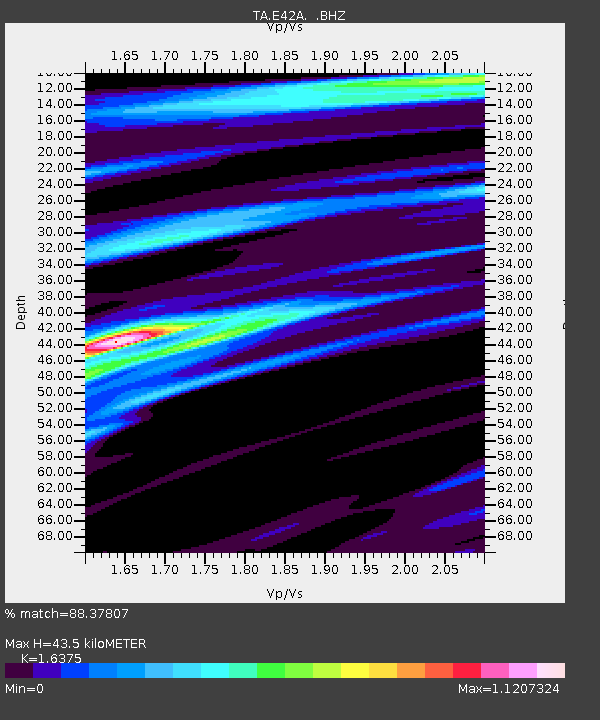
E42A Champion, MI, USA - Earthquake Result Viewer
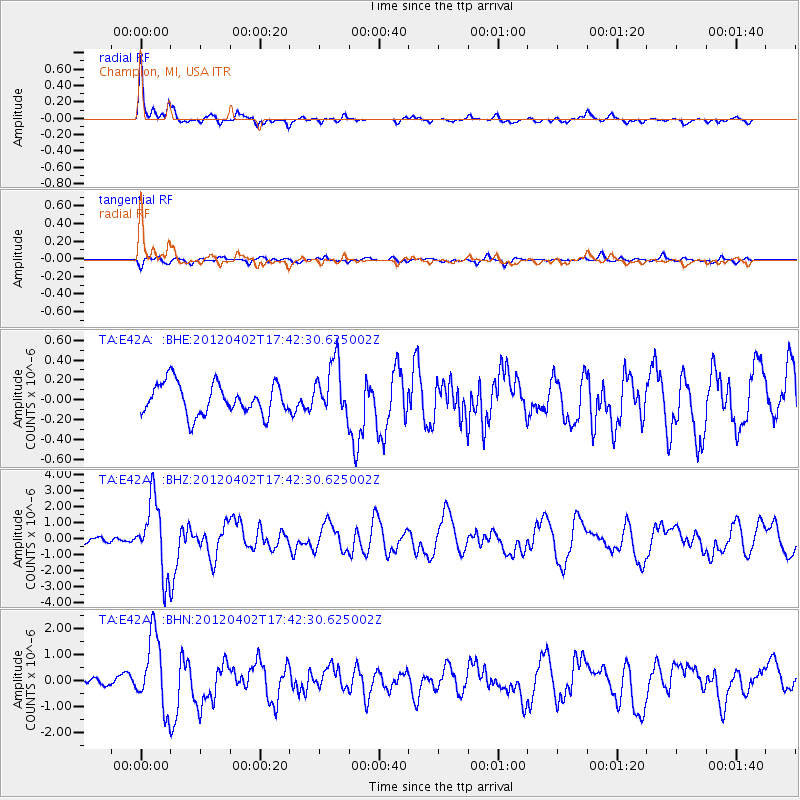
Earthquake location: Near Coast Of Guerrero, Mexico
Earthquake latitude/longitude: 16.4/-98.3
Earthquake time(UTC): 2012/04/02 (093) 17:36:42 GMT
Earthquake Depth: 9.0 km
Earthquake Magnitude: 5.8 MB, 5.9 MS, 6.0 MW, 6.0 MW
Earthquake Catalog/Contributor: WHDF/NEIC
Network: TA USArray Transportable Network (new EarthScope stations)
Station: E42A Champion, MI, USA
Lat/Lon: 46.43 N/87.91 W
Elevation: 475 m
Distance: 31.2 deg
Az: 13.96 deg
Baz: 199.559 deg
Ray Param: 0.07913932
Estimated Moho Depth: 43.5 km
Estimated Crust Vp/Vs: 1.64
Assumed Crust Vp: 6.472 km/s
Estimated Crust Vs: 3.952 km/s
Estimated Crust Poisson's Ratio: 0.20
Radial Match: 88.37807 %
Radial Bump: 365
Transverse Match: 66.12042 %
Transverse Bump: 400
SOD ConfigId: 445498
Insert Time: 2012-06-23 04:47:42.209 +0000
GWidth: 2.5
Max Bumps: 400
Tol: 0.001

Signal To Noise

ChannelStoNSTALTA
TA:E42A: :BHZ:20120402T17:42:30.625002Z9.7414842.2676738E-62.3278524E-7
TA:E42A: :BHN:20120402T17:42:30.625002Z7.23660561.4066475E-61.9437945E-7
TA:E42A: :BHE:20120402T17:42:30.625002Z1.73162952.7155613E-71.5682116E-7
Arrivals
Ps4.7 SECOND
PpPs16 SECOND
PsPs/PpSs21 SECOND