You are here: Home > Network List > TA - USArray Transportable Network (new EarthScope stations) Stations List
> Station F44A Big Bay de Noc Black Bears, Cooks, MI, USA > Earthquake Result Viewer
F44A Big Bay de Noc Black Bears, Cooks, MI, USA - Earthquake Result Viewer
| Earthquake location: |
Near Coast Of Guerrero, Mexico |
| Earthquake latitude/longitude: |
16.4/-98.3 |
| Earthquake time(UTC): |
2012/04/02 (093) 17:36:42 GMT |
| Earthquake Depth: |
9.0 km |
| Earthquake Magnitude: |
5.8 MB, 5.9 MS, 6.0 MW, 6.0 MW |
| Earthquake Catalog/Contributor: |
WHDF/NEIC |
|
| Network: |
TA USArray Transportable Network (new EarthScope stations) |
| Station: |
F44A Big Bay de Noc Black Bears, Cooks, MI, USA |
| Lat/Lon: |
45.97 N/86.42 W |
| Elevation: |
234 m |
|
| Distance: |
31.1 deg |
| Az: |
16.146 deg |
| Baz: |
202.503 deg |
| Ray Param: |
0.079153605 |
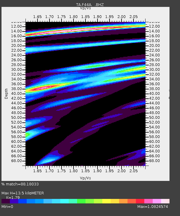
| Estimated Moho Depth: |
13.5 km |
| Estimated Crust Vp/Vs: |
1.79 |
| Assumed Crust Vp: |
6.53 km/s |
| Estimated Crust Vs: |
3.648 km/s |
| Estimated Crust Poisson's Ratio: |
0.27 |
|
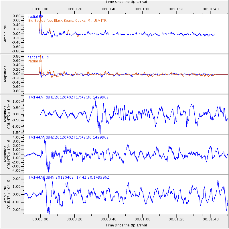
| Radial Match: |
88.18033 % |
| Radial Bump: |
375 |
| Transverse Match: |
69.182976 % |
| Transverse Bump: |
400 |
| SOD ConfigId: |
445498 |
| Insert Time: |
2012-06-23 04:48:06.552 +0000 |
| GWidth: |
2.5 |
| Max Bumps: |
400 |
| Tol: |
0.001 |
|
Signal To Noise
| Channel | StoN | STA | LTA |
| TA:F44A: :BHZ:20120402T17:42:30.149996Z | 8.398467 | 2.4183798E-6 | 2.879549E-7 |
| TA:F44A: :BHN:20120402T17:42:30.149996Z | 6.3640656 | 1.3503569E-6 | 2.1218464E-7 |
| TA:F44A: :BHE:20120402T17:42:30.149996Z | 4.034103 | 6.909118E-7 | 1.7126777E-7 |
| Arrivals |
| Ps | 1.8 SECOND |
| PpPs | 5.3 SECOND |
| PsPs/PpSs | 7.1 SECOND |


