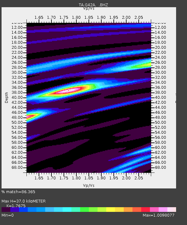
G42A Mountain, WI, USA - Earthquake Result Viewer
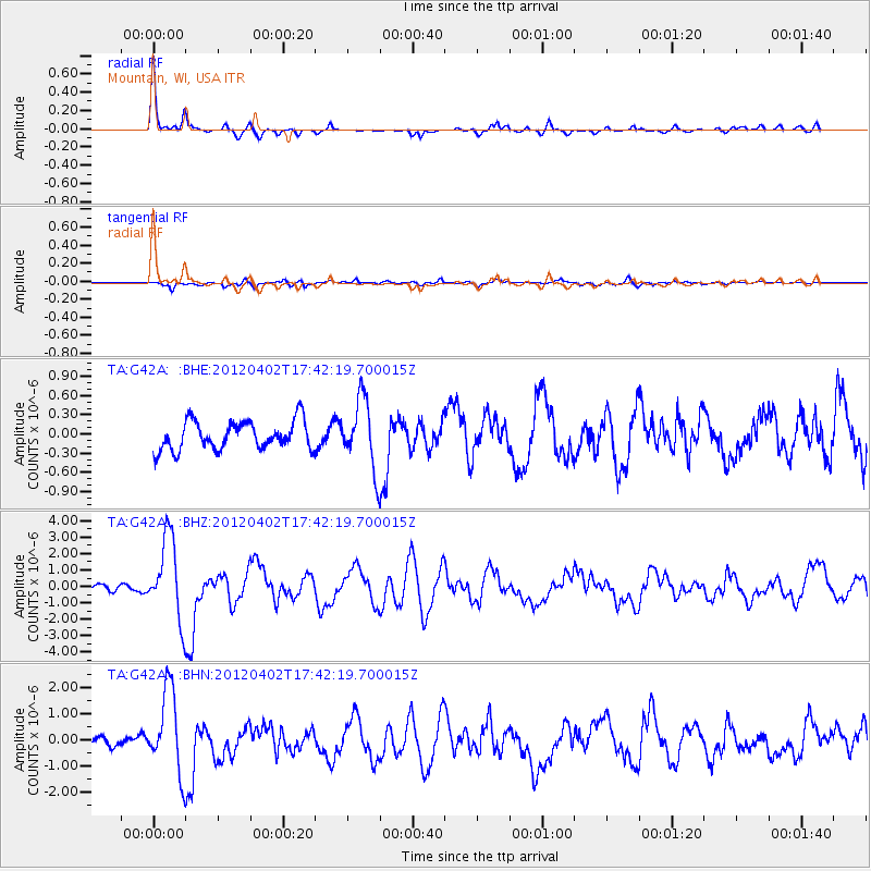
Earthquake location: Near Coast Of Guerrero, Mexico
Earthquake latitude/longitude: 16.4/-98.3
Earthquake time(UTC): 2012/04/02 (093) 17:36:42 GMT
Earthquake Depth: 9.0 km
Earthquake Magnitude: 5.8 MB, 5.9 MS, 6.0 MW, 6.0 MW
Earthquake Catalog/Contributor: WHDF/NEIC
Network: TA USArray Transportable Network (new EarthScope stations)
Station: G42A Mountain, WI, USA
Lat/Lon: 45.24 N/88.43 W
Elevation: 315 m
Distance: 29.9 deg
Az: 14.071 deg
Baz: 199.287 deg
Ray Param: 0.07946517
Estimated Moho Depth: 37.0 km
Estimated Crust Vp/Vs: 1.77
Assumed Crust Vp: 6.41 km/s
Estimated Crust Vs: 3.627 km/s
Estimated Crust Poisson's Ratio: 0.26
Radial Match: 86.365 %
Radial Bump: 275
Transverse Match: 60.152058 %
Transverse Bump: 400
SOD ConfigId: 445498
Insert Time: 2012-06-23 04:48:32.771 +0000
GWidth: 2.5
Max Bumps: 400
Tol: 0.001

Signal To Noise

ChannelStoNSTALTA
TA:G42A: :BHZ:20120402T17:42:19.700015Z7.88368132.4730841E-63.1369663E-7
TA:G42A: :BHN:20120402T17:42:19.700015Z9.9268881.5669366E-61.5784771E-7
TA:G42A: :BHE:20120402T17:42:19.700015Z2.42563375.410428E-72.2305215E-7
Arrivals
Ps4.8 SECOND
PpPs15 SECOND
PsPs/PpSs20 SECOND