You are here: Home > Network List > TA - USArray Transportable Network (new EarthScope stations) Stations List
> Station F46A Macinaw City Comets, Mackinaw City, MI, USA > Earthquake Result Viewer
F46A Macinaw City Comets, Mackinaw City, MI, USA - Earthquake Result Viewer
| Earthquake location: |
Near Coast Of Guerrero, Mexico |
| Earthquake latitude/longitude: |
16.4/-98.3 |
| Earthquake time(UTC): |
2012/04/02 (093) 17:36:42 GMT |
| Earthquake Depth: |
9.0 km |
| Earthquake Magnitude: |
5.8 MB, 5.9 MS, 6.0 MW, 6.0 MW |
| Earthquake Catalog/Contributor: |
WHDF/NEIC |
|
| Network: |
TA USArray Transportable Network (new EarthScope stations) |
| Station: |
F46A Macinaw City Comets, Mackinaw City, MI, USA |
| Lat/Lon: |
45.77 N/84.76 W |
| Elevation: |
198 m |
|
| Distance: |
31.4 deg |
| Az: |
18.348 deg |
| Baz: |
205.576 deg |
| Ray Param: |
0.07907717 |
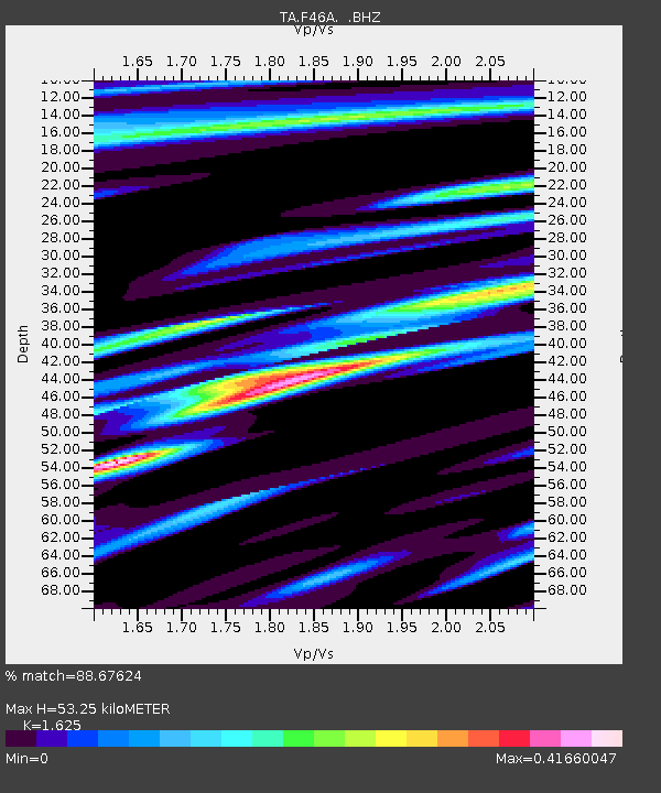
| Estimated Moho Depth: |
53.25 km |
| Estimated Crust Vp/Vs: |
1.62 |
| Assumed Crust Vp: |
6.483 km/s |
| Estimated Crust Vs: |
3.989 km/s |
| Estimated Crust Poisson's Ratio: |
0.20 |
|
| Radial Match: |
88.67624 % |
| Radial Bump: |
366 |
| Transverse Match: |
70.04264 % |
| Transverse Bump: |
400 |
| SOD ConfigId: |
445498 |
| Insert Time: |
2012-06-23 04:48:45.767 +0000 |
| GWidth: |
2.5 |
| Max Bumps: |
400 |
| Tol: |
0.001 |
|

Signal To Noise
| Channel | StoN | STA | LTA |
| TA:F46A: :BHZ:20120402T17:42:32.700015Z | 10.04238 | 3.0334645E-6 | 3.0206627E-7 |
| TA:F46A: :BHN:20120402T17:42:32.700015Z | 5.6881146 | 1.6113175E-6 | 2.8327796E-7 |
| TA:F46A: :BHE:20120402T17:42:32.700015Z | 2.7996542 | 5.6580495E-7 | 2.0209816E-7 |
| Arrivals |
| Ps | 5.6 SECOND |
| PpPs | 20 SECOND |
| PsPs/PpSs | 25 SECOND |


