You are here: Home > Network List > UW - Pacific Northwest Regional Seismic Network Stations List
> Station BLOW Detroit Lake, OR, USA > Earthquake Result Viewer
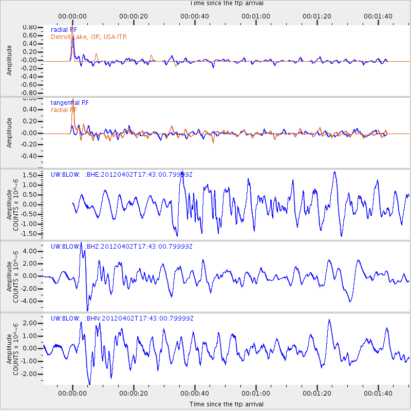
BLOW Detroit Lake, OR, USA - Earthquake Result Viewer
*The percent match for this event was below the threshold and hence no stack was calculated.
| Earthquake location: |
Near Coast Of Guerrero, Mexico |
| Earthquake latitude/longitude: |
16.4/-98.3 |
| Earthquake time(UTC): |
2012/04/02 (093) 17:36:42 GMT |
| Earthquake Depth: |
9.0 km |
| Earthquake Magnitude: |
5.8 MB, 5.9 MS, 6.0 MW, 6.0 MW |
| Earthquake Catalog/Contributor: |
WHDF/NEIC |
|
| Network: |
UW Pacific Northwest Regional Seismic Network |
| Station: |
BLOW Detroit Lake, OR, USA |
| Lat/Lon: |
44.68 N/122.19 W |
| Elevation: |
652 m |
|
| Distance: |
34.6 deg |
| Az: |
329.48 deg |
| Baz: |
136.896 deg |
| Ray Param: |
$rayparam |
*The percent match for this event was below the threshold and hence was not used in the summary stack. |
|
| Radial Match: |
76.728 % |
| Radial Bump: |
400 |
| Transverse Match: |
65.74897 % |
| Transverse Bump: |
400 |
| SOD ConfigId: |
445498 |
| Insert Time: |
2012-06-23 04:50:35.042 +0000 |
| GWidth: |
2.5 |
| Max Bumps: |
400 |
| Tol: |
0.001 |
|
Signal To Noise
| Channel | StoN | STA | LTA |
| UW:BLOW: :BHZ:20120402T17:43:00.79999Z | 4.5065637 | 2.6429118E-6 | 5.864583E-7 |
| UW:BLOW: :BHN:20120402T17:43:00.79999Z | 1.9681932 | 8.9906297E-7 | 4.567961E-7 |
| UW:BLOW: :BHE:20120402T17:43:00.79999Z | 1.9907426 | 7.0937904E-7 | 3.5633892E-7 |
| Arrivals |
| Ps | |
| PpPs | |
| PsPs/PpSs | |


