You are here: Home > Network List > TA - USArray Transportable Network (new EarthScope stations) Stations List
> Station Z41A Richland Creek Farm, El Dorado, AR, USA > Earthquake Result Viewer
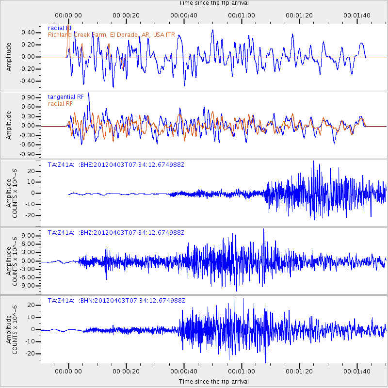
Z41A Richland Creek Farm, El Dorado, AR, USA - Earthquake Result Viewer
*The percent match for this event was below the threshold and hence no stack was calculated.
| Earthquake location: |
Northern Chile |
| Earthquake latitude/longitude: |
-19.6/-69.1 |
| Earthquake time(UTC): |
2012/04/03 (094) 07:25:08 GMT |
| Earthquake Depth: |
117 km |
| Earthquake Magnitude: |
5.5 ML, 5.2 MB |
| Earthquake Catalog/Contributor: |
WHDF/NEIC |
|
| Network: |
TA USArray Transportable Network (new EarthScope stations) |
| Station: |
Z41A Richland Creek Farm, El Dorado, AR, USA |
| Lat/Lon: |
33.26 N/92.80 W |
| Elevation: |
62 m |
|
| Distance: |
57.3 deg |
| Az: |
336.388 deg |
| Baz: |
153.22 deg |
| Ray Param: |
$rayparam |
*The percent match for this event was below the threshold and hence was not used in the summary stack. |
|
| Radial Match: |
46.59205 % |
| Radial Bump: |
400 |
| Transverse Match: |
56.15453 % |
| Transverse Bump: |
400 |
| SOD ConfigId: |
445498 |
| Insert Time: |
2012-06-23 05:18:02.650 +0000 |
| GWidth: |
2.5 |
| Max Bumps: |
400 |
| Tol: |
0.001 |
|
Signal To Noise
| Channel | StoN | STA | LTA |
| TA:Z41A: :BHZ:20120403T07:34:12.674988Z | 2.0148394 | 4.2955634E-7 | 2.131963E-7 |
| TA:Z41A: :BHN:20120403T07:34:12.674988Z | 0.82494915 | 4.2648438E-7 | 5.169826E-7 |
| TA:Z41A: :BHE:20120403T07:34:12.674988Z | 0.35854992 | 1.6890587E-7 | 4.710805E-7 |
| Arrivals |
| Ps | |
| PpPs | |
| PsPs/PpSs | |


