You are here: Home > Network List > TA - USArray Transportable Network (new EarthScope stations) Stations List
> Station M39A Webster, IA, USA > Earthquake Result Viewer
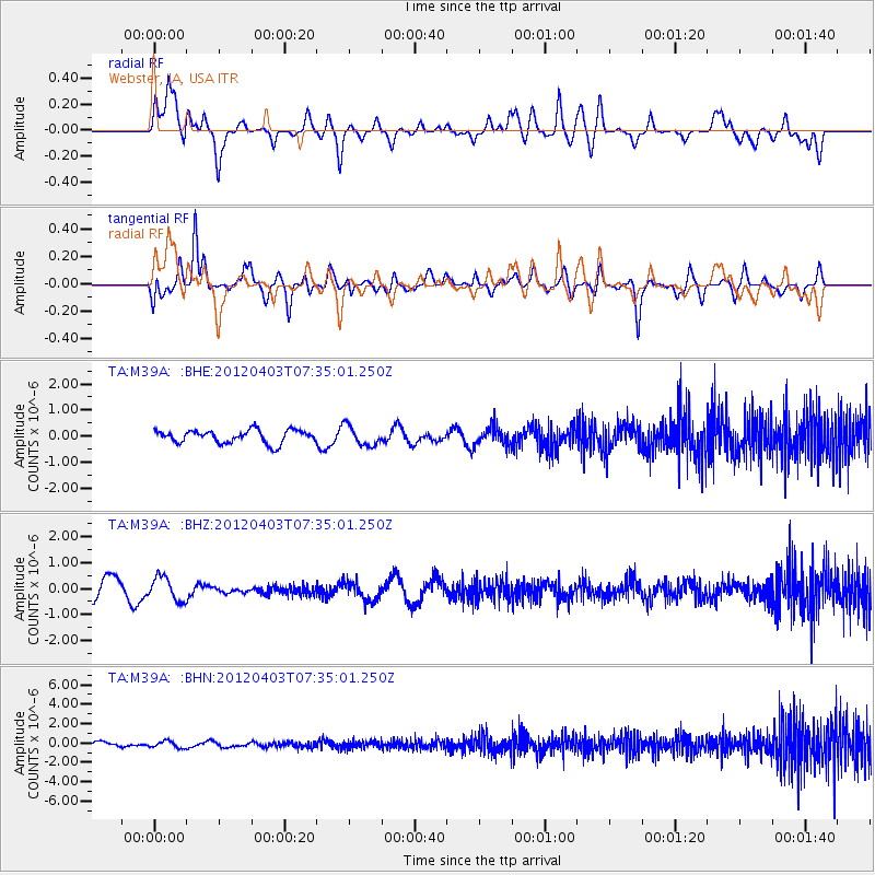
M39A Webster, IA, USA - Earthquake Result Viewer
*The percent match for this event was below the threshold and hence no stack was calculated.
| Earthquake location: |
Northern Chile |
| Earthquake latitude/longitude: |
-19.6/-69.1 |
| Earthquake time(UTC): |
2012/04/03 (094) 07:25:08 GMT |
| Earthquake Depth: |
117 km |
| Earthquake Magnitude: |
5.5 ML, 5.2 MB |
| Earthquake Catalog/Contributor: |
WHDF/NEIC |
|
| Network: |
TA USArray Transportable Network (new EarthScope stations) |
| Station: |
M39A Webster, IA, USA |
| Lat/Lon: |
41.48 N/92.17 W |
| Elevation: |
264 m |
|
| Distance: |
64.5 deg |
| Az: |
340.946 deg |
| Baz: |
155.827 deg |
| Ray Param: |
$rayparam |
*The percent match for this event was below the threshold and hence was not used in the summary stack. |
|
| Radial Match: |
66.27076 % |
| Radial Bump: |
400 |
| Transverse Match: |
77.46275 % |
| Transverse Bump: |
400 |
| SOD ConfigId: |
445498 |
| Insert Time: |
2012-06-23 05:19:22.203 +0000 |
| GWidth: |
2.5 |
| Max Bumps: |
400 |
| Tol: |
0.001 |
|
Signal To Noise
| Channel | StoN | STA | LTA |
| TA:M39A: :BHZ:20120403T07:35:01.250Z | 0.9649778 | 4.5803878E-7 | 4.7466253E-7 |
| TA:M39A: :BHN:20120403T07:35:01.250Z | 1.1281568 | 3.4401216E-7 | 3.0493294E-7 |
| TA:M39A: :BHE:20120403T07:35:01.250Z | 1.5087436 | 3.7649195E-7 | 2.4954005E-7 |
| Arrivals |
| Ps | |
| PpPs | |
| PsPs/PpSs | |


