You are here: Home > Network List > TA - USArray Transportable Network (new EarthScope stations) Stations List
> Station P42A Winchester, IL, USA > Earthquake Result Viewer
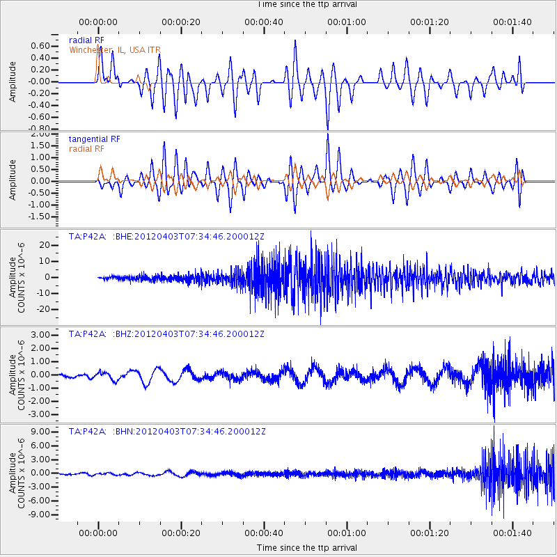
P42A Winchester, IL, USA - Earthquake Result Viewer
*The percent match for this event was below the threshold and hence no stack was calculated.
| Earthquake location: |
Northern Chile |
| Earthquake latitude/longitude: |
-19.6/-69.1 |
| Earthquake time(UTC): |
2012/04/03 (094) 07:25:08 GMT |
| Earthquake Depth: |
117 km |
| Earthquake Magnitude: |
5.5 ML, 5.2 MB |
| Earthquake Catalog/Contributor: |
WHDF/NEIC |
|
| Network: |
TA USArray Transportable Network (new EarthScope stations) |
| Station: |
P42A Winchester, IL, USA |
| Lat/Lon: |
39.59 N/90.34 W |
| Elevation: |
197 m |
|
| Distance: |
62.2 deg |
| Az: |
341.535 deg |
| Baz: |
157.275 deg |
| Ray Param: |
$rayparam |
*The percent match for this event was below the threshold and hence was not used in the summary stack. |
|
| Radial Match: |
27.462654 % |
| Radial Bump: |
400 |
| Transverse Match: |
21.77207 % |
| Transverse Bump: |
400 |
| SOD ConfigId: |
445498 |
| Insert Time: |
2012-06-23 05:19:36.842 +0000 |
| GWidth: |
2.5 |
| Max Bumps: |
400 |
| Tol: |
0.001 |
|
Signal To Noise
| Channel | StoN | STA | LTA |
| TA:P42A: :BHZ:20120403T07:34:46.200012Z | 1.1092402 | 3.0040422E-7 | 2.708198E-7 |
| TA:P42A: :BHN:20120403T07:34:46.200012Z | 1.1566356 | 1.9055125E-7 | 1.6474614E-7 |
| TA:P42A: :BHE:20120403T07:34:46.200012Z | 2.4239864 | 3.660661E-6 | 1.5101821E-6 |
| Arrivals |
| Ps | |
| PpPs | |
| PsPs/PpSs | |


