You are here: Home > Network List > TA - USArray Transportable Network (new EarthScope stations) Stations List
> Station L40A Anamosa, IA, USA > Earthquake Result Viewer
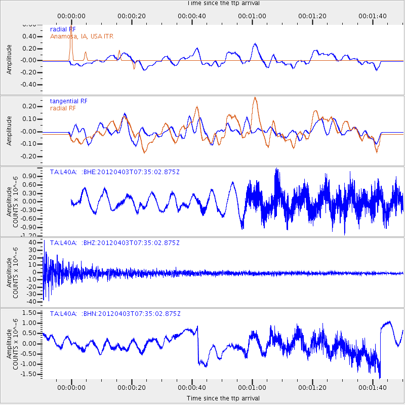
L40A Anamosa, IA, USA - Earthquake Result Viewer
*The percent match for this event was below the threshold and hence no stack was calculated.
| Earthquake location: |
Northern Chile |
| Earthquake latitude/longitude: |
-19.6/-69.1 |
| Earthquake time(UTC): |
2012/04/03 (094) 07:25:08 GMT |
| Earthquake Depth: |
117 km |
| Earthquake Magnitude: |
5.5 ML, 5.2 MB |
| Earthquake Catalog/Contributor: |
WHDF/NEIC |
|
| Network: |
TA USArray Transportable Network (new EarthScope stations) |
| Station: |
L40A Anamosa, IA, USA |
| Lat/Lon: |
42.06 N/91.22 W |
| Elevation: |
242 m |
|
| Distance: |
64.7 deg |
| Az: |
341.927 deg |
| Baz: |
156.879 deg |
| Ray Param: |
$rayparam |
*The percent match for this event was below the threshold and hence was not used in the summary stack. |
|
| Radial Match: |
47.819546 % |
| Radial Bump: |
400 |
| Transverse Match: |
57.9964 % |
| Transverse Bump: |
400 |
| SOD ConfigId: |
445498 |
| Insert Time: |
2012-06-23 05:19:48.816 +0000 |
| GWidth: |
2.5 |
| Max Bumps: |
400 |
| Tol: |
0.001 |
|
Signal To Noise
| Channel | StoN | STA | LTA |
| TA:L40A: :BHZ:20120403T07:35:02.875Z | 0.7217918 | 6.1753058E-6 | 8.555522E-6 |
| TA:L40A: :BHN:20120403T07:35:02.875Z | 0.3717216 | 1.984102E-7 | 5.337602E-7 |
| TA:L40A: :BHE:20120403T07:35:02.875Z | 1.0759295 | 2.4711616E-7 | 2.296769E-7 |
| Arrivals |
| Ps | |
| PpPs | |
| PsPs/PpSs | |


