You are here: Home > Network List > G - GEOSCOPE Stations List
> Station INU Inuyama, Japan > Earthquake Result Viewer
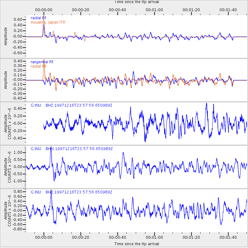
INU Inuyama, Japan - Earthquake Result Viewer
*The percent match for this event was below the threshold and hence no stack was calculated.
| Earthquake location: |
Eastern New Guinea Reg., P.N.G. |
| Earthquake latitude/longitude: |
-5.9/147.2 |
| Earthquake time(UTC): |
1997/12/16 (350) 23:50:45 GMT |
| Earthquake Depth: |
103 km |
| Earthquake Magnitude: |
5.7 MB, 5.8 UNKNOWN, 5.8 MW |
| Earthquake Catalog/Contributor: |
WHDF/NEIC |
|
| Network: |
G GEOSCOPE |
| Station: |
INU Inuyama, Japan |
| Lat/Lon: |
35.35 N/137.03 E |
| Elevation: |
132 m |
|
| Distance: |
42.1 deg |
| Az: |
347.606 deg |
| Baz: |
164.859 deg |
| Ray Param: |
$rayparam |
*The percent match for this event was below the threshold and hence was not used in the summary stack. |
|
| Radial Match: |
59.420284 % |
| Radial Bump: |
392 |
| Transverse Match: |
56.21928 % |
| Transverse Bump: |
400 |
| SOD ConfigId: |
4480 |
| Insert Time: |
2010-02-26 23:26:33.357 +0000 |
| GWidth: |
2.5 |
| Max Bumps: |
400 |
| Tol: |
0.001 |
|
Signal To Noise
| Channel | StoN | STA | LTA |
| G:INU: :BHN:19971216T23:57:56.650989Z | 2.9395428 | 4.4845407E-7 | 1.5255912E-7 |
| G:INU: :BHE:19971216T23:57:56.650989Z | 1.7080319 | 3.001074E-7 | 1.7570362E-7 |
| G:INU: :BHZ:19971216T23:57:56.650989Z | 0.66880035 | 7.4743625E-8 | 1.1175775E-7 |
| Arrivals |
| Ps | |
| PpPs | |
| PsPs/PpSs | |


