You are here: Home > Network List > G - GEOSCOPE Stations List
> Station INU Inuyama, Japan > Earthquake Result Viewer
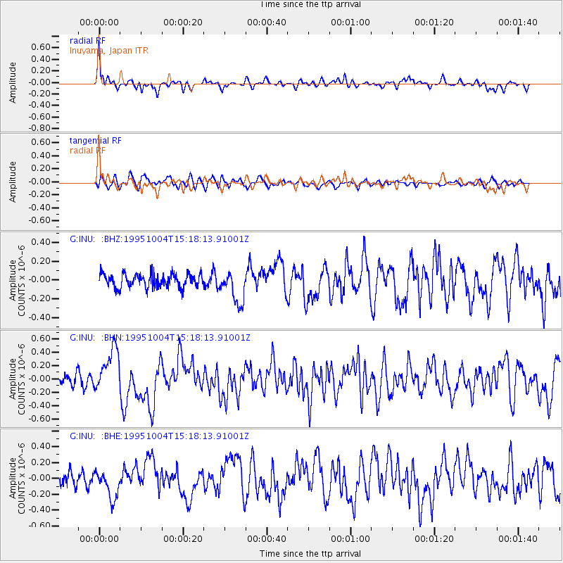
INU Inuyama, Japan - Earthquake Result Viewer
*The percent match for this event was below the threshold and hence no stack was calculated.
| Earthquake location: |
Near Islands, Aleutian Islands |
| Earthquake latitude/longitude: |
52.7/172.5 |
| Earthquake time(UTC): |
1995/10/04 (277) 15:12:34 GMT |
| Earthquake Depth: |
33 km |
| Earthquake Magnitude: |
5.6 MB, 5.4 MS, 5.5 UNKNOWN, 5.9 MW |
| Earthquake Catalog/Contributor: |
WHDF/NEIC |
|
| Network: |
G GEOSCOPE |
| Station: |
INU Inuyama, Japan |
| Lat/Lon: |
35.35 N/137.03 E |
| Elevation: |
132 m |
|
| Distance: |
30.4 deg |
| Az: |
249.395 deg |
| Baz: |
44.157 deg |
| Ray Param: |
$rayparam |
*The percent match for this event was below the threshold and hence was not used in the summary stack. |
|
| Radial Match: |
64.34624 % |
| Radial Bump: |
400 |
| Transverse Match: |
64.363655 % |
| Transverse Bump: |
400 |
| SOD ConfigId: |
4480 |
| Insert Time: |
2010-02-26 23:26:33.859 +0000 |
| GWidth: |
2.5 |
| Max Bumps: |
400 |
| Tol: |
0.001 |
|
Signal To Noise
| Channel | StoN | STA | LTA |
| G:INU: :BHN:19951004T15:18:13.91001Z | 3.5794759 | 3.393292E-7 | 9.479857E-8 |
| G:INU: :BHE:19951004T15:18:13.91001Z | 1.8679698 | 1.8408822E-7 | 9.85499E-8 |
| G:INU: :BHZ:19951004T15:18:13.91001Z | 2.5164797 | 1.7763294E-7 | 7.0587866E-8 |
| Arrivals |
| Ps | |
| PpPs | |
| PsPs/PpSs | |


