You are here: Home > Network List > GT - Global Telemetered Seismograph Network (USAF/USGS) Stations List
> Station LPAZ La Paz , Bolivia > Earthquake Result Viewer
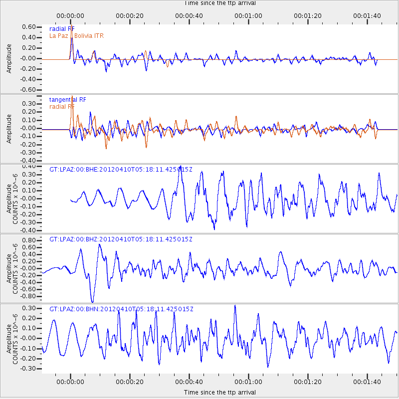
LPAZ La Paz , Bolivia - Earthquake Result Viewer
*The percent match for this event was below the threshold and hence no stack was calculated.
| Earthquake location: |
North Of Ascension Island |
| Earthquake latitude/longitude: |
-1.3/-14.0 |
| Earthquake time(UTC): |
2012/04/10 (101) 05:09:08 GMT |
| Earthquake Depth: |
10 km |
| Earthquake Magnitude: |
5.8 MW, 5.4 MS, 5.4 MB, 5.8 MW |
| Earthquake Catalog/Contributor: |
WHDF/NEIC |
|
| Network: |
GT Global Telemetered Seismograph Network (USAF/USGS) |
| Station: |
LPAZ La Paz , Bolivia |
| Lat/Lon: |
16.17 S/68.08 W |
| Elevation: |
4817 m |
|
| Distance: |
55.3 deg |
| Az: |
251.238 deg |
| Baz: |
80.107 deg |
| Ray Param: |
$rayparam |
*The percent match for this event was below the threshold and hence was not used in the summary stack. |
|
| Radial Match: |
68.36792 % |
| Radial Bump: |
400 |
| Transverse Match: |
51.572815 % |
| Transverse Bump: |
400 |
| SOD ConfigId: |
446234 |
| Insert Time: |
2012-07-04 09:00:23.420 +0000 |
| GWidth: |
2.5 |
| Max Bumps: |
400 |
| Tol: |
0.001 |
|
Signal To Noise
| Channel | StoN | STA | LTA |
| GT:LPAZ:00:BHZ:20120410T05:18:11.425015Z | 1.9148006 | 2.5000566E-7 | 1.3056484E-7 |
| GT:LPAZ:00:BHN:20120410T05:18:11.425015Z | 1.6177374 | 1.1269894E-7 | 6.9664544E-8 |
| GT:LPAZ:00:BHE:20120410T05:18:11.425015Z | 1.9567736 | 1.273041E-7 | 6.505817E-8 |
| Arrivals |
| Ps | |
| PpPs | |
| PsPs/PpSs | |


