You are here: Home > Network List > TA - USArray Transportable Network (new EarthScope stations) Stations List
> Station Z46A Louisville, MS, USA > Earthquake Result Viewer
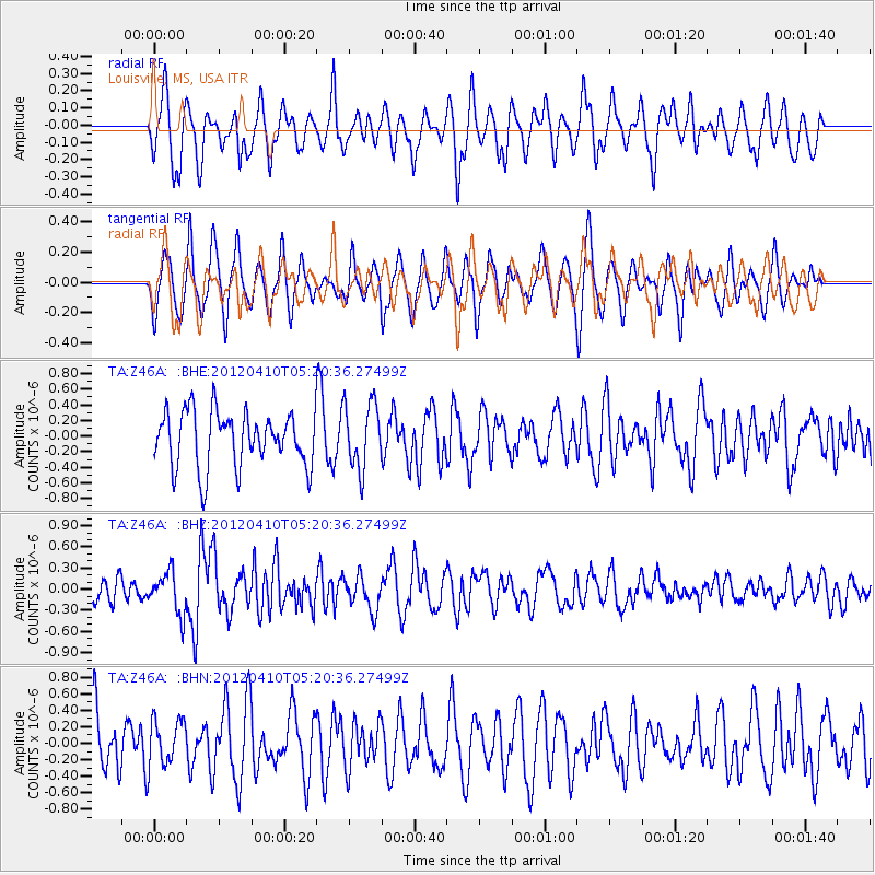
Z46A Louisville, MS, USA - Earthquake Result Viewer
*The percent match for this event was below the threshold and hence no stack was calculated.
| Earthquake location: |
North Of Ascension Island |
| Earthquake latitude/longitude: |
-1.3/-14.0 |
| Earthquake time(UTC): |
2012/04/10 (101) 05:09:08 GMT |
| Earthquake Depth: |
10 km |
| Earthquake Magnitude: |
5.8 MW, 5.4 MS, 5.4 MB, 5.8 MW |
| Earthquake Catalog/Contributor: |
WHDF/NEIC |
|
| Network: |
TA USArray Transportable Network (new EarthScope stations) |
| Station: |
Z46A Louisville, MS, USA |
| Lat/Lon: |
33.19 N/88.94 W |
| Elevation: |
125 m |
|
| Distance: |
78.1 deg |
| Az: |
304.159 deg |
| Baz: |
99.386 deg |
| Ray Param: |
$rayparam |
*The percent match for this event was below the threshold and hence was not used in the summary stack. |
|
| Radial Match: |
53.16586 % |
| Radial Bump: |
400 |
| Transverse Match: |
58.81596 % |
| Transverse Bump: |
400 |
| SOD ConfigId: |
446234 |
| Insert Time: |
2012-07-04 09:07:25.819 +0000 |
| GWidth: |
2.5 |
| Max Bumps: |
400 |
| Tol: |
0.001 |
|
Signal To Noise
| Channel | StoN | STA | LTA |
| TA:Z46A: :BHZ:20120410T05:20:36.27499Z | 2.0703008 | 2.9072834E-7 | 1.4042806E-7 |
| TA:Z46A: :BHN:20120410T05:20:36.27499Z | 0.7139015 | 2.7697783E-7 | 3.8797768E-7 |
| TA:Z46A: :BHE:20120410T05:20:36.27499Z | 1.1845243 | 4.215238E-7 | 3.5585913E-7 |
| Arrivals |
| Ps | |
| PpPs | |
| PsPs/PpSs | |


