You are here: Home > Network List > G - GEOSCOPE Stations List
> Station INU Inuyama, Japan > Earthquake Result Viewer
INU Inuyama, Japan - Earthquake Result Viewer
*The percent match for this event was below the threshold and hence no stack was calculated.
| Earthquake location: |
Northern Molucca Sea |
| Earthquake latitude/longitude: |
2.0/126.5 |
| Earthquake time(UTC): |
1994/02/20 (051) 01:54:36 GMT |
| Earthquake Depth: |
33 km |
| Earthquake Magnitude: |
5.6 MB, 5.6 MS, 5.4 UNKNOWN |
| Earthquake Catalog/Contributor: |
WHDF/NEIC |
|
| Network: |
G GEOSCOPE |
| Station: |
INU Inuyama, Japan |
| Lat/Lon: |
35.35 N/137.03 E |
| Elevation: |
132 m |
|
| Distance: |
34.5 deg |
| Az: |
15.263 deg |
| Baz: |
198.773 deg |
| Ray Param: |
$rayparam |
*The percent match for this event was below the threshold and hence was not used in the summary stack. |
|
| Radial Match: |
79.00036 % |
| Radial Bump: |
400 |
| Transverse Match: |
72.74358 % |
| Transverse Bump: |
400 |
| SOD ConfigId: |
4480 |
| Insert Time: |
2010-02-26 23:26:55.360 +0000 |
| GWidth: |
2.5 |
| Max Bumps: |
400 |
| Tol: |
0.001 |
|
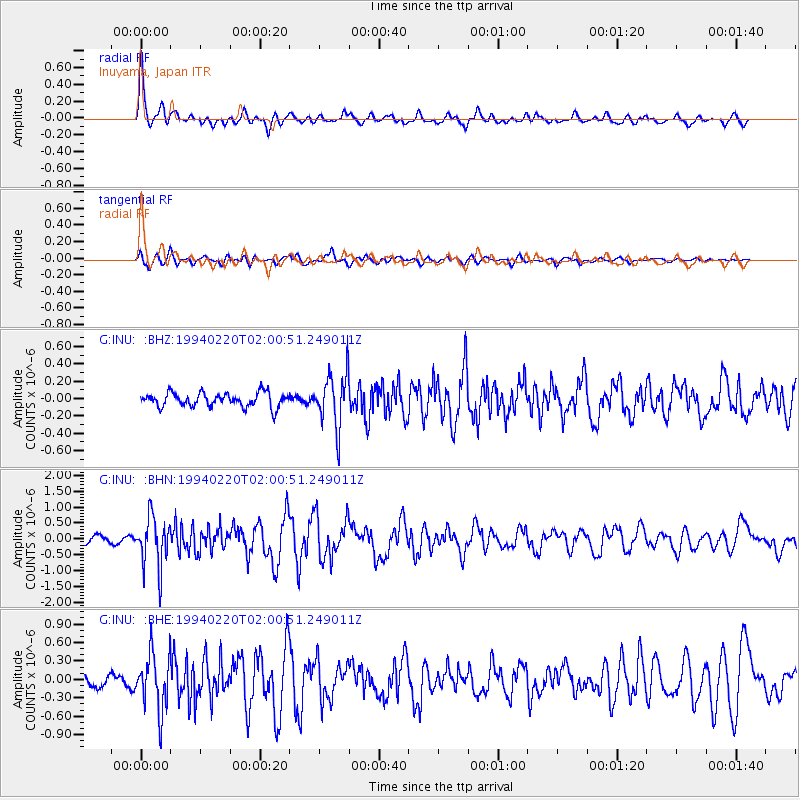
Signal To Noise
| Channel | StoN | STA | LTA |
| G:INU: :BHN:19940220T02:00:51.249011Z | 9.003211 | 7.883466E-7 | 8.756283E-8 |
| G:INU: :BHE:19940220T02:00:51.249011Z | 5.225491 | 4.627598E-7 | 8.855814E-8 |
| G:INU: :BHZ:19940220T02:00:51.249011Z | 3.8526537 | 3.081907E-7 | 7.999439E-8 |
| Arrivals |
| Ps | |
| PpPs | |
| PsPs/PpSs | |


