You are here: Home > Network List > TA - USArray Transportable Network (new EarthScope stations) Stations List
> Station U42A Revenden, AR, USA > Earthquake Result Viewer
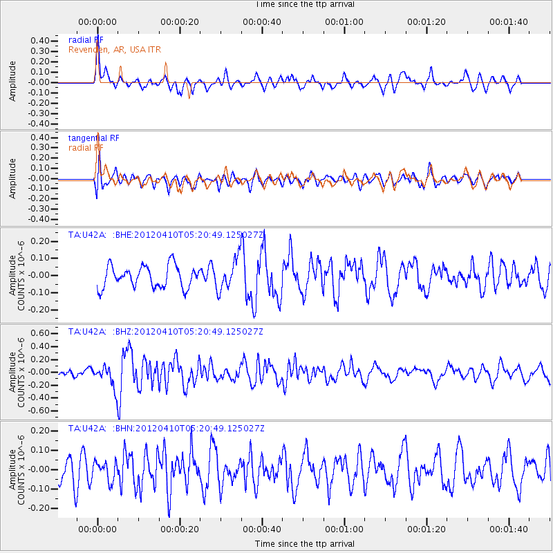
U42A Revenden, AR, USA - Earthquake Result Viewer
*The percent match for this event was below the threshold and hence no stack was calculated.
| Earthquake location: |
North Of Ascension Island |
| Earthquake latitude/longitude: |
-1.3/-14.0 |
| Earthquake time(UTC): |
2012/04/10 (101) 05:09:08 GMT |
| Earthquake Depth: |
10 km |
| Earthquake Magnitude: |
5.8 MW, 5.4 MS, 5.4 MB, 5.8 MW |
| Earthquake Catalog/Contributor: |
WHDF/NEIC |
|
| Network: |
TA USArray Transportable Network (new EarthScope stations) |
| Station: |
U42A Revenden, AR, USA |
| Lat/Lon: |
36.35 N/91.24 W |
| Elevation: |
119 m |
|
| Distance: |
80.5 deg |
| Az: |
307.024 deg |
| Baz: |
98.612 deg |
| Ray Param: |
$rayparam |
*The percent match for this event was below the threshold and hence was not used in the summary stack. |
|
| Radial Match: |
55.006767 % |
| Radial Bump: |
372 |
| Transverse Match: |
53.005985 % |
| Transverse Bump: |
400 |
| SOD ConfigId: |
446234 |
| Insert Time: |
2012-07-04 09:08:52.904 +0000 |
| GWidth: |
2.5 |
| Max Bumps: |
400 |
| Tol: |
0.001 |
|
Signal To Noise
| Channel | StoN | STA | LTA |
| TA:U42A: :BHZ:20120410T05:20:49.125027Z | 2.7819722 | 1.7646526E-7 | 6.343171E-8 |
| TA:U42A: :BHN:20120410T05:20:49.125027Z | 0.7523731 | 5.0636512E-8 | 6.7302395E-8 |
| TA:U42A: :BHE:20120410T05:20:49.125027Z | 1.5188588 | 9.5582976E-8 | 6.293079E-8 |
| Arrivals |
| Ps | |
| PpPs | |
| PsPs/PpSs | |


