You are here: Home > Network List > TA - USArray Transportable Network (new EarthScope stations) Stations List
> Station I41A Arkdale, WI, USA > Earthquake Result Viewer
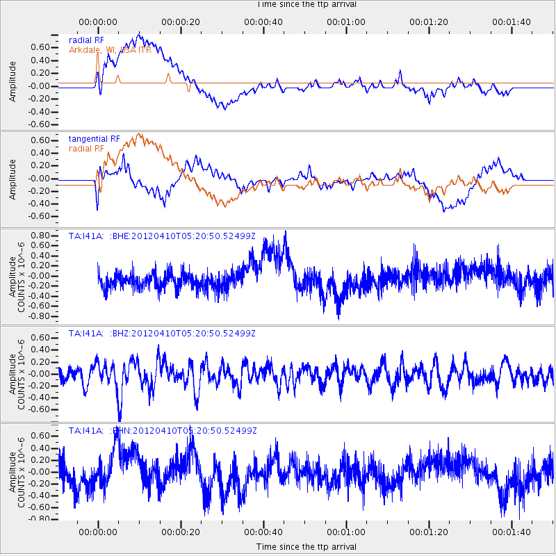
I41A Arkdale, WI, USA - Earthquake Result Viewer
*The percent match for this event was below the threshold and hence no stack was calculated.
| Earthquake location: |
North Of Ascension Island |
| Earthquake latitude/longitude: |
-1.3/-14.0 |
| Earthquake time(UTC): |
2012/04/10 (101) 05:09:08 GMT |
| Earthquake Depth: |
10 km |
| Earthquake Magnitude: |
5.8 MW, 5.4 MS, 5.4 MB, 5.8 MW |
| Earthquake Catalog/Contributor: |
WHDF/NEIC |
|
| Network: |
TA USArray Transportable Network (new EarthScope stations) |
| Station: |
I41A Arkdale, WI, USA |
| Lat/Lon: |
44.06 N/89.87 W |
| Elevation: |
289 m |
|
| Distance: |
80.8 deg |
| Az: |
314.895 deg |
| Baz: |
100.777 deg |
| Ray Param: |
$rayparam |
*The percent match for this event was below the threshold and hence was not used in the summary stack. |
|
| Radial Match: |
49.411022 % |
| Radial Bump: |
400 |
| Transverse Match: |
41.726303 % |
| Transverse Bump: |
400 |
| SOD ConfigId: |
446234 |
| Insert Time: |
2012-07-04 09:09:23.884 +0000 |
| GWidth: |
2.5 |
| Max Bumps: |
400 |
| Tol: |
0.001 |
|
Signal To Noise
| Channel | StoN | STA | LTA |
| TA:I41A: :BHZ:20120410T05:20:50.52499Z | 1.526643 | 1.8912571E-7 | 1.2388338E-7 |
| TA:I41A: :BHN:20120410T05:20:50.52499Z | 1.7462754 | 3.4376572E-7 | 1.9685652E-7 |
| TA:I41A: :BHE:20120410T05:20:50.52499Z | 1.1802727 | 1.6834318E-7 | 1.4263074E-7 |
| Arrivals |
| Ps | |
| PpPs | |
| PsPs/PpSs | |


