You are here: Home > Network List > TA - USArray Transportable Network (new EarthScope stations) Stations List
> Station W46A Michie, TN, USA > Earthquake Result Viewer
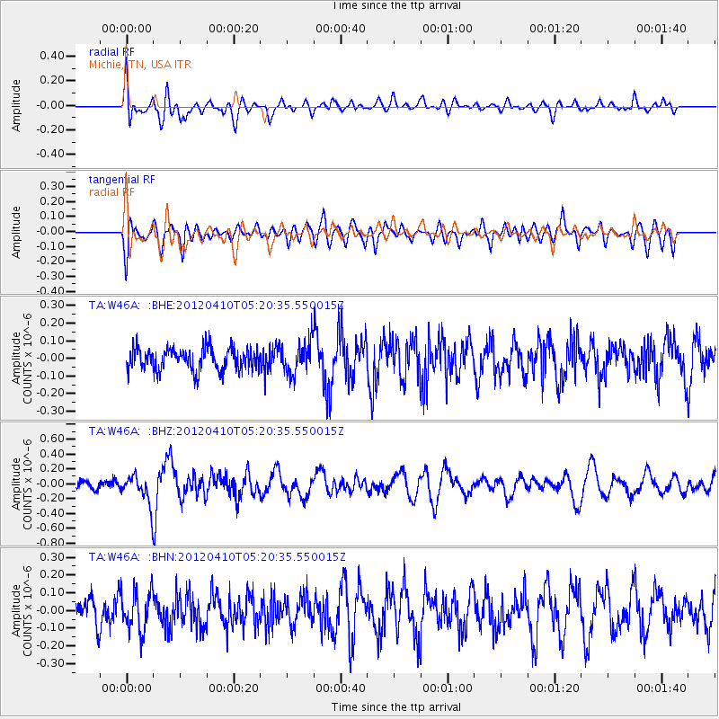
W46A Michie, TN, USA - Earthquake Result Viewer
*The percent match for this event was below the threshold and hence no stack was calculated.
| Earthquake location: |
North Of Ascension Island |
| Earthquake latitude/longitude: |
-1.3/-14.0 |
| Earthquake time(UTC): |
2012/04/10 (101) 05:09:08 GMT |
| Earthquake Depth: |
10 km |
| Earthquake Magnitude: |
5.8 MW, 5.4 MS, 5.4 MB, 5.8 MW |
| Earthquake Catalog/Contributor: |
WHDF/NEIC |
|
| Network: |
TA USArray Transportable Network (new EarthScope stations) |
| Station: |
W46A Michie, TN, USA |
| Lat/Lon: |
35.13 N/88.38 W |
| Elevation: |
145 m |
|
| Distance: |
78.0 deg |
| Az: |
306.189 deg |
| Baz: |
100.12 deg |
| Ray Param: |
$rayparam |
*The percent match for this event was below the threshold and hence was not used in the summary stack. |
|
| Radial Match: |
66.3619 % |
| Radial Bump: |
400 |
| Transverse Match: |
58.756023 % |
| Transverse Bump: |
400 |
| SOD ConfigId: |
446234 |
| Insert Time: |
2012-07-04 09:11:14.947 +0000 |
| GWidth: |
2.5 |
| Max Bumps: |
400 |
| Tol: |
0.001 |
|
Signal To Noise
| Channel | StoN | STA | LTA |
| TA:W46A: :BHZ:20120410T05:20:35.550015Z | 2.131803 | 1.9480592E-7 | 9.138083E-8 |
| TA:W46A: :BHN:20120410T05:20:35.550015Z | 1.3544593 | 1.0969152E-7 | 8.0985465E-8 |
| TA:W46A: :BHE:20120410T05:20:35.550015Z | 1.3957223 | 8.713704E-8 | 6.2431496E-8 |
| Arrivals |
| Ps | |
| PpPs | |
| PsPs/PpSs | |


