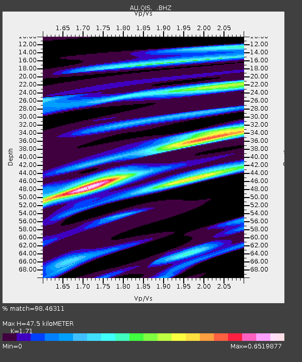
QIS Mount Isa, Queensland - Earthquake Result Viewer

Earthquake location: Off W Coast Of Northern Sumatra
Earthquake latitude/longitude: 2.3/93.1
Earthquake time(UTC): 2012/04/11 (102) 08:38:36 GMT
Earthquake Depth: 20 km
Earthquake Magnitude: 7.4 MB, 8.5 MS, 8.6 MW, 8.6 MW
Earthquake Catalog/Contributor: WHDF/NEIC
Network: AU Australian Seismological Centre
Station: QIS Mount Isa, Queensland
Lat/Lon: 20.56 S/139.61 E
Elevation: 450 m
Distance: 51.0 deg
Az: 118.855 deg
Baz: 290.951 deg
Ray Param: 0.06769247
Estimated Moho Depth: 47.5 km
Estimated Crust Vp/Vs: 1.71
Assumed Crust Vp: 6.577 km/s
Estimated Crust Vs: 3.846 km/s
Estimated Crust Poisson's Ratio: 0.24
Radial Match: 98.46311 %
Radial Bump: 224
Transverse Match: 97.02458 %
Transverse Bump: 400
SOD ConfigId: 446234
Insert Time: 2012-07-04 09:18:12.701 +0000
GWidth: 2.5
Max Bumps: 400
Tol: 0.001

Signal To Noise

ChannelStoNSTALTA
AU:QIS: :BHZ:20120411T08:47:05.869994Z13.4790885.0323133E-63.733423E-7
AU:QIS: :BHN:20120411T08:47:05.869994Z1.79019311.9880058E-71.1104979E-7
AU:QIS: :BHE:20120411T08:47:05.869994Z11.1001163.2466526E-62.9248818E-7
Arrivals
Ps5.5 SECOND
PpPs18 SECOND
PsPs/PpSs24 SECOND