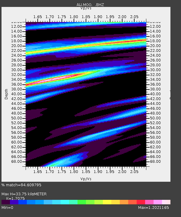
MOO Moorlands, Tasmania - Earthquake Result Viewer

Earthquake location: Off W Coast Of Northern Sumatra
Earthquake latitude/longitude: 2.3/93.1
Earthquake time(UTC): 2012/04/11 (102) 08:38:36 GMT
Earthquake Depth: 20 km
Earthquake Magnitude: 7.4 MB, 8.5 MS, 8.6 MW, 8.6 MW
Earthquake Catalog/Contributor: WHDF/NEIC
Network: AU Australian Seismological Centre
Station: MOO Moorlands, Tasmania
Lat/Lon: 42.44 S/147.19 E
Elevation: 325 m
Distance: 66.0 deg
Az: 138.972 deg
Baz: 297.614 deg
Ray Param: 0.057863392
Estimated Moho Depth: 33.75 km
Estimated Crust Vp/Vs: 1.71
Assumed Crust Vp: 6.477 km/s
Estimated Crust Vs: 3.793 km/s
Estimated Crust Poisson's Ratio: 0.24
Radial Match: 94.609795 %
Radial Bump: 400
Transverse Match: 85.495995 %
Transverse Bump: 400
SOD ConfigId: 446234
Insert Time: 2012-07-04 09:19:18.544 +0000
GWidth: 2.5
Max Bumps: 400
Tol: 0.001

Signal To Noise

ChannelStoNSTALTA
AU:MOO: :BHZ:20120411T08:48:50.769988Z4.59279632.6689559E-65.811178E-7
AU:MOO: :BHN:20120411T08:48:50.769988Z1.86469675.6560367E-73.0332208E-7
AU:MOO: :BHE:20120411T08:48:50.769988Z3.56070381.2269591E-63.445833E-7
Arrivals
Ps3.8 SECOND
PpPs14 SECOND
PsPs/PpSs17 SECOND