You are here: Home > Network List > G - GEOSCOPE Stations List
> Station INU Inuyama, Japan > Earthquake Result Viewer
INU Inuyama, Japan - Earthquake Result Viewer

| Earthquake location: |
Off W Coast Of Northern Sumatra |
| Earthquake latitude/longitude: |
2.3/93.1 |
| Earthquake time(UTC): |
2012/04/11 (102) 08:38:36 GMT |
| Earthquake Depth: |
20 km |
| Earthquake Magnitude: |
7.4 MB, 8.5 MS, 8.6 MW, 8.6 MW |
| Earthquake Catalog/Contributor: |
WHDF/NEIC |
|
| Network: |
G GEOSCOPE |
| Station: |
INU Inuyama, Japan |
| Lat/Lon: |
35.35 N/137.03 E |
| Elevation: |
132 m |
|
| Distance: |
52.3 deg |
| Az: |
45.805 deg |
| Baz: |
241.206 deg |
| Ray Param: |
0.0668046 |
| Estimated Moho Depth: |
69.25 km |
| Estimated Crust Vp/Vs: |
2.02 |
| Assumed Crust Vp: |
6.461 km/s |
| Estimated Crust Vs: |
3.207 km/s |
| Estimated Crust Poisson's Ratio: |
0.34 |
|
| Radial Match: |
96.69793 % |
| Radial Bump: |
400 |
| Transverse Match: |
85.10929 % |
| Transverse Bump: |
400 |
| SOD ConfigId: |
446234 |
| Insert Time: |
2012-07-04 09:21:37.207 +0000 |
| GWidth: |
2.5 |
| Max Bumps: |
400 |
| Tol: |
0.001 |
|
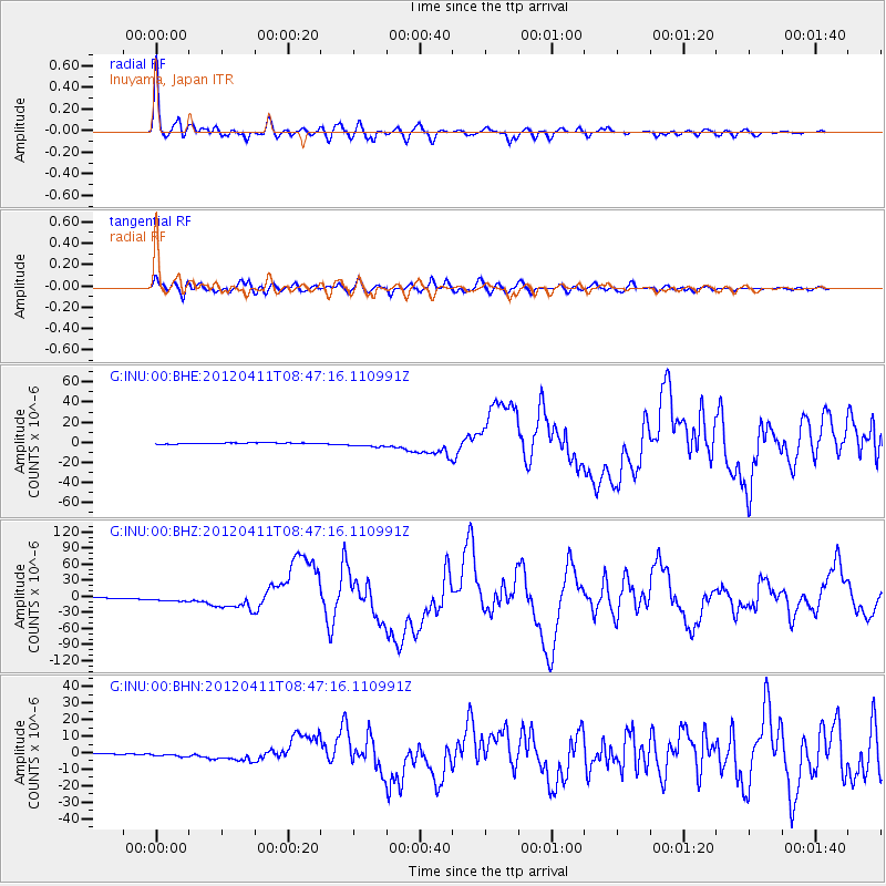
Signal To Noise
| Channel | StoN | STA | LTA |
| G:INU:00:BHZ:20120411T08:47:16.110991Z | 7.260818 | 5.170055E-6 | 7.120486E-7 |
| G:INU:00:BHN:20120411T08:47:16.110991Z | 3.1735282 | 1.1751918E-6 | 3.703108E-7 |
| G:INU:00:BHE:20120411T08:47:16.110991Z | 5.721106 | 2.8165337E-6 | 4.923058E-7 |
| Arrivals |
| Ps | 11 SECOND |
| PpPs | 31 SECOND |
| PsPs/PpSs | 42 SECOND |


