You are here: Home > Network List > G - GEOSCOPE Stations List
> Station INU Inuyama, Japan > Earthquake Result Viewer
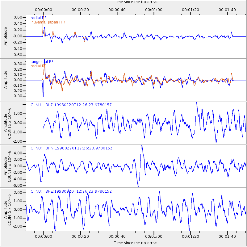
INU Inuyama, Japan - Earthquake Result Viewer
*The percent match for this event was below the threshold and hence no stack was calculated.
| Earthquake location: |
Afghanistan-Tajikistan Bord Reg. |
| Earthquake latitude/longitude: |
36.5/71.1 |
| Earthquake time(UTC): |
1998/02/20 (051) 12:18:06 GMT |
| Earthquake Depth: |
236 km |
| Earthquake Magnitude: |
5.8 MB, 5.7 MS, 6.4 UNKNOWN, 6.3 MW |
| Earthquake Catalog/Contributor: |
WHDF/NEIC |
|
| Network: |
G GEOSCOPE |
| Station: |
INU Inuyama, Japan |
| Lat/Lon: |
35.35 N/137.03 E |
| Elevation: |
132 m |
|
| Distance: |
52.4 deg |
| Az: |
70.32 deg |
| Baz: |
291.819 deg |
| Ray Param: |
$rayparam |
*The percent match for this event was below the threshold and hence was not used in the summary stack. |
|
| Radial Match: |
67.63916 % |
| Radial Bump: |
400 |
| Transverse Match: |
67.670944 % |
| Transverse Bump: |
400 |
| SOD ConfigId: |
4480 |
| Insert Time: |
2010-02-26 23:27:08.770 +0000 |
| GWidth: |
2.5 |
| Max Bumps: |
400 |
| Tol: |
0.001 |
|
Signal To Noise
| Channel | StoN | STA | LTA |
| G:INU: :BHN:19980220T12:26:23.978015Z | 1.8730501 | 2.0483199E-6 | 1.0935746E-6 |
| G:INU: :BHE:19980220T12:26:23.978015Z | 0.9754466 | 9.783977E-7 | 1.0030254E-6 |
| G:INU: :BHZ:19980220T12:26:23.978015Z | 1.2729115 | 8.301193E-7 | 6.5214215E-7 |
| Arrivals |
| Ps | |
| PpPs | |
| PsPs/PpSs | |


