You are here: Home > Network List > IC - New China Digital Seismograph Network Stations List
> Station BJT Baijiatuan, Beijing, China > Earthquake Result Viewer
BJT Baijiatuan, Beijing, China - Earthquake Result Viewer
| Earthquake location: |
Off W Coast Of Northern Sumatra |
| Earthquake latitude/longitude: |
2.3/93.1 |
| Earthquake time(UTC): |
2012/04/11 (102) 08:38:36 GMT |
| Earthquake Depth: |
20 km |
| Earthquake Magnitude: |
7.4 MB, 8.5 MS, 8.6 MW, 8.6 MW |
| Earthquake Catalog/Contributor: |
WHDF/NEIC |
|
| Network: |
IC New China Digital Seismograph Network |
| Station: |
BJT Baijiatuan, Beijing, China |
| Lat/Lon: |
40.02 N/116.17 E |
| Elevation: |
197 m |
|
| Distance: |
43.0 deg |
| Az: |
26.235 deg |
| Baz: |
215.111 deg |
| Ray Param: |
0.07281999 |
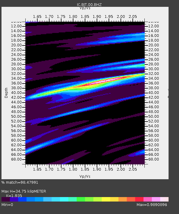
| Estimated Moho Depth: |
34.75 km |
| Estimated Crust Vp/Vs: |
1.93 |
| Assumed Crust Vp: |
6.464 km/s |
| Estimated Crust Vs: |
3.34 km/s |
| Estimated Crust Poisson's Ratio: |
0.32 |
|
| Radial Match: |
98.47991 % |
| Radial Bump: |
260 |
| Transverse Match: |
89.05062 % |
| Transverse Bump: |
400 |
| SOD ConfigId: |
446234 |
| Insert Time: |
2012-07-04 09:22:52.596 +0000 |
| GWidth: |
2.5 |
| Max Bumps: |
400 |
| Tol: |
0.001 |
|
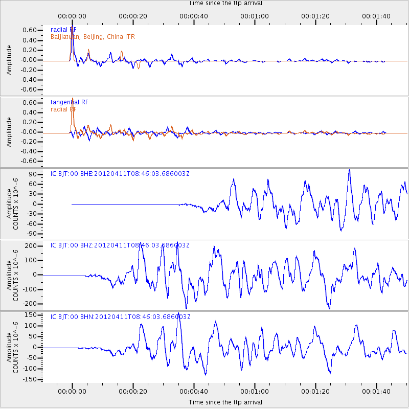
Signal To Noise
| Channel | StoN | STA | LTA |
| IC:BJT:00:BHZ:20120411T08:46:03.686003Z | 8.940422 | 1.5504415E-6 | 1.7341927E-7 |
| IC:BJT:00:BHN:20120411T08:46:03.686003Z | 1.0089924 | 4.3419388E-7 | 4.3032423E-7 |
| IC:BJT:00:BHE:20120411T08:46:03.686003Z | 2.007637 | 1.9970555E-7 | 9.947294E-8 |
| Arrivals |
| Ps | 5.3 SECOND |
| PpPs | 15 SECOND |
| PsPs/PpSs | 20 SECOND |


