You are here: Home > Network List > II - Global Seismograph Network (GSN - IRIS/IDA) Stations List
> Station MBAR Mbarara, Uganda > Earthquake Result Viewer
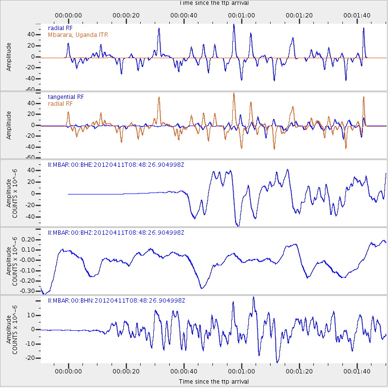
MBAR Mbarara, Uganda - Earthquake Result Viewer
*The percent match for this event was below the threshold and hence no stack was calculated.
| Earthquake location: |
Off W Coast Of Northern Sumatra |
| Earthquake latitude/longitude: |
2.3/93.1 |
| Earthquake time(UTC): |
2012/04/11 (102) 08:38:36 GMT |
| Earthquake Depth: |
20 km |
| Earthquake Magnitude: |
7.4 MB, 8.5 MS, 8.6 MW, 8.6 MW |
| Earthquake Catalog/Contributor: |
WHDF/NEIC |
|
| Network: |
II Global Seismograph Network (GSN - IRIS/IDA) |
| Station: |
MBAR Mbarara, Uganda |
| Lat/Lon: |
0.60 S/30.74 E |
| Elevation: |
1390 m |
|
| Distance: |
62.4 deg |
| Az: |
268.114 deg |
| Baz: |
87.078 deg |
| Ray Param: |
$rayparam |
*The percent match for this event was below the threshold and hence was not used in the summary stack. |
|
| Radial Match: |
61.02604 % |
| Radial Bump: |
400 |
| Transverse Match: |
41.289562 % |
| Transverse Bump: |
400 |
| SOD ConfigId: |
446234 |
| Insert Time: |
2012-07-04 09:23:11.729 +0000 |
| GWidth: |
2.5 |
| Max Bumps: |
400 |
| Tol: |
0.001 |
|
Signal To Noise
| Channel | StoN | STA | LTA |
| II:MBAR:00:BHZ:20120411T08:48:26.904998Z | 0.1992078 | 5.445548E-8 | 2.7336017E-7 |
| II:MBAR:00:BHN:20120411T08:48:26.904998Z | 2.1745927 | 1.7372197E-7 | 7.988712E-8 |
| II:MBAR:00:BHE:20120411T08:48:26.904998Z | 6.927223 | 2.764456E-6 | 3.9907133E-7 |
| Arrivals |
| Ps | |
| PpPs | |
| PsPs/PpSs | |


